

During my travels, I’ve been fortunate to see and experience much that is worth sharing.
My hope is that these images touch your hearts, much as the USA’s natural beauty has touched mine.
May the adventurous among you benefit from the travel information I share on these pages!
Before you are misled by the title of this post, I must warn you that you will see no photos of prairie chicks or fawns here (although I eventually caught a fawn on camera in the Rockies, which you can see in this post). I set out to capture images of North Dakota’s Little Missouri River valley on a warm summer day in 2008, and that is pretty much what I did.
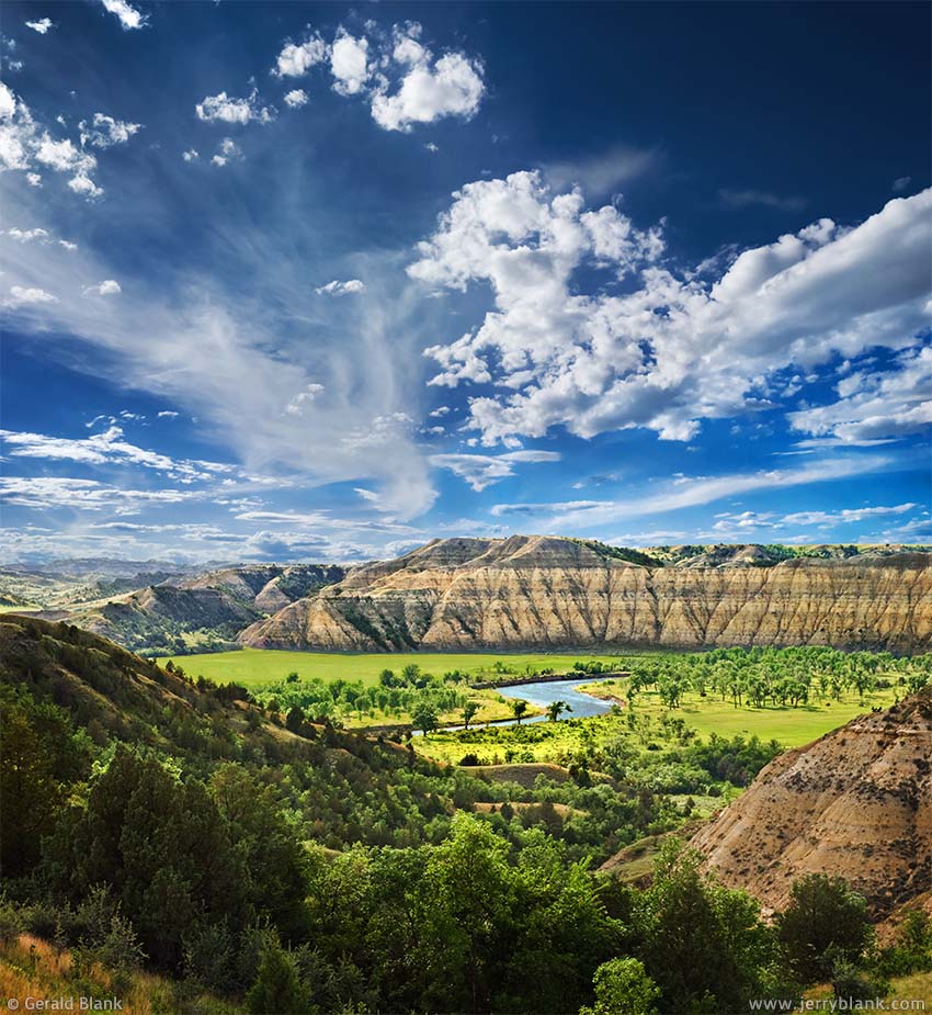
Looking across the Little Missouri River valley — Click / tap image to view full size
The Little Missouri River, and the Little Missouri National Grassland which surrounds it, provides most of the really fine scenery which western North Dakota has to offer. The river also runs through Theodore Roosevelt National Park, which is a good place to visit if you want some good views of the river, and of the bison and bighorn sheep which can be found there.
In the summer of 2008, I made a goal of finding and photographing as many of the best views of the Little Missouri River as I could, especially those places which could be accessed by the many miles of public back roads which wind through the National Grassland. These views are largely unknown by travelers to Theodore Roosevelt National Park, and to most folks who live in North Dakota, for that matter.
I often find that in spite of my careful planning, I don’t always get the photos I expect to. But just as often, I get some nice surprises I don’t expect, which more than makes up for it. June 20, 2008 was such a day. I had worked my way south along the Little Missouri River, following the back roads from McKenzie County down into Billings County, but by early afternoon I had found few scenes worth stopping for.
Following a dusty 2-track trail on my way to Goat Pass Road, I had to stop my SUV abruptly to avoid a prairie hen and a bunch of her chicks crossing the trail. They scrambled down the embankment at my right to take shelter in the shady underbrush on the left side. But the chick in the back of the line turned around at the last moment, too fearful to trust the guidance of its mom. Feeling cornered, it struggled vainly to climb back up the loose dusty soil of the embankment. I turned my car off and walked over to the embankment to see how I could help.
“You’re never going to make it up that way,” I advised the chick, picking it up carefully. “Let me put you over there in the brush with your mom.”
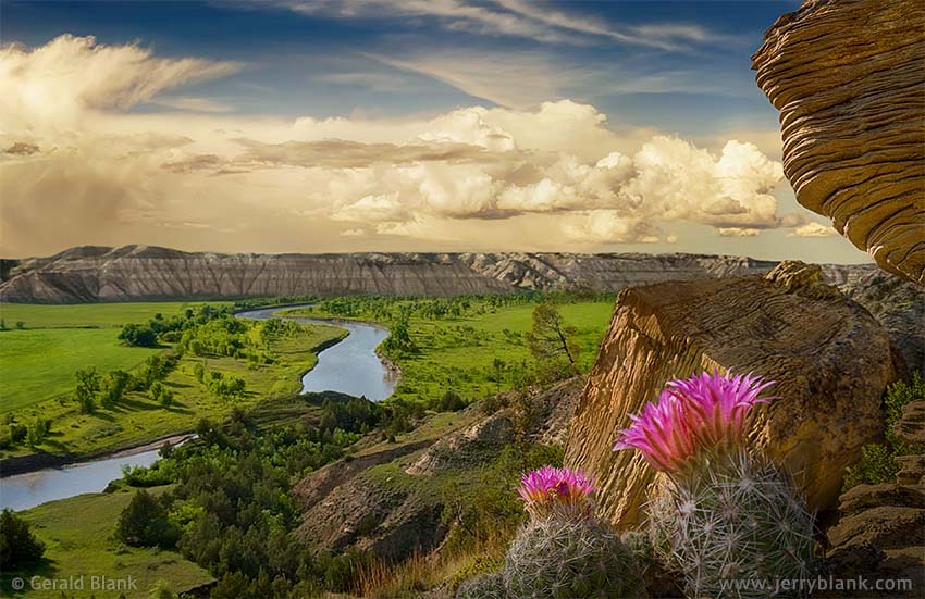
Pincushion cactus and sandstone — Click / tap image to view full size
The chick was now positively panicked. I guess it was an inbred fear of larger creatures, since no chicks living in 2008 would have seen a Chick-Fil-A ad campaign. I walked slowly across the road with the bird cupped in my hands. I wanted to make the moment last longer, but was more concerned about the struggling bird’s welfare, so I set it down quickly but gently in the brush, pleading: “Just hang around for a bit while I get my camera, okay?” Fat chance. The moment its feet hit the ground, it dashed away in the direction of its family.
Even though I had no photo to show for the experience, I savored the moment of satisfaction as I restarted my car and headed north, back to McKenzie County. I’d never helped an old lady across the street when I was a Boy Scout, but that afternoon made up for it. And not long thereafter, I finally found a nice view of the Little Missouri River near an oil well access road, and captured the photo displayed at the top of this post.
At another oil well site a little farther north, I stepped out of the car without my camera to gaze across the river and consider my options. As soon as I stopped walking noisily through the steep brush-covered slopes above the river, I heard a rustling in the grass to my left and whirled round, expecting to find a rabbit.
No rabbit did I find, but a tiny fawn which I would never have noticed, had it not lost its nerve and stumbled to its feet. As it did so, it lost its balance on the steep slope and got its front leg wedged between two branches of the juniper shrub under which it was hiding, and now it was obviously in trouble. When I was young, my first reaction would have been to run back uphill for my camera! But after the experience of raising a son, I could not leave the fawn tangled up in that shrub—no more than I’d leave my son in such pitiful condition. The fawn’s leg had to be freed quickly, before it got sprained or broken.
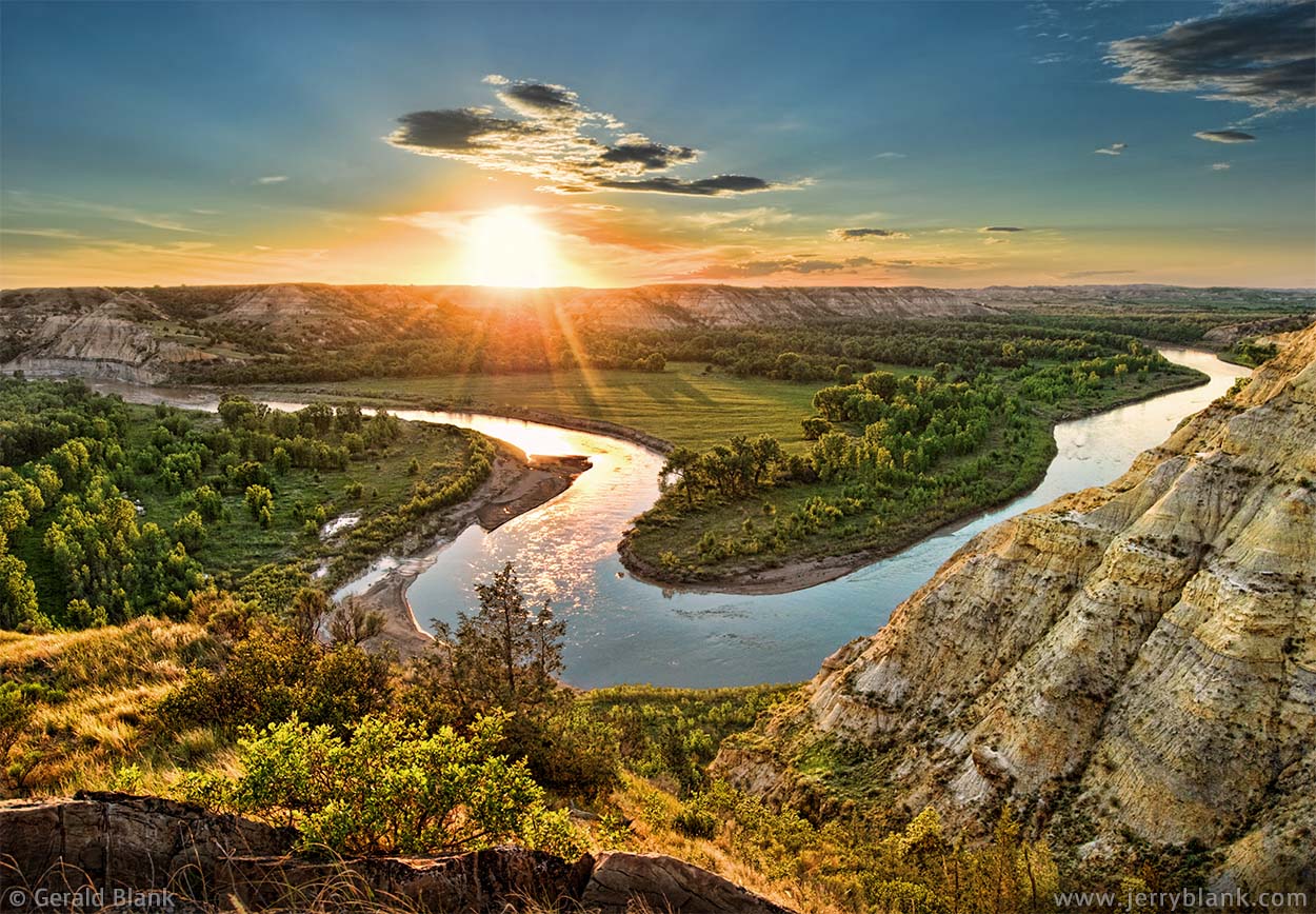
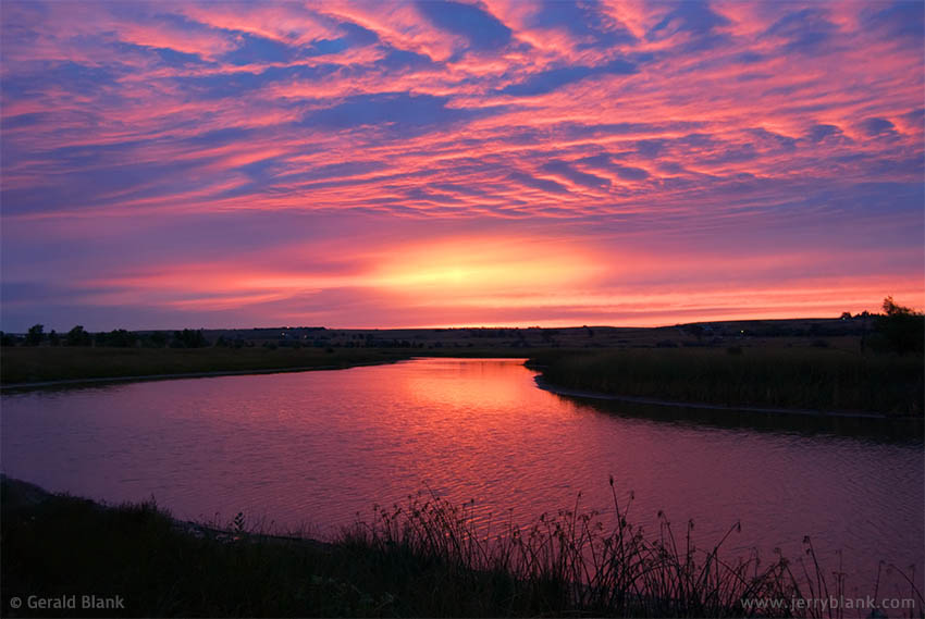
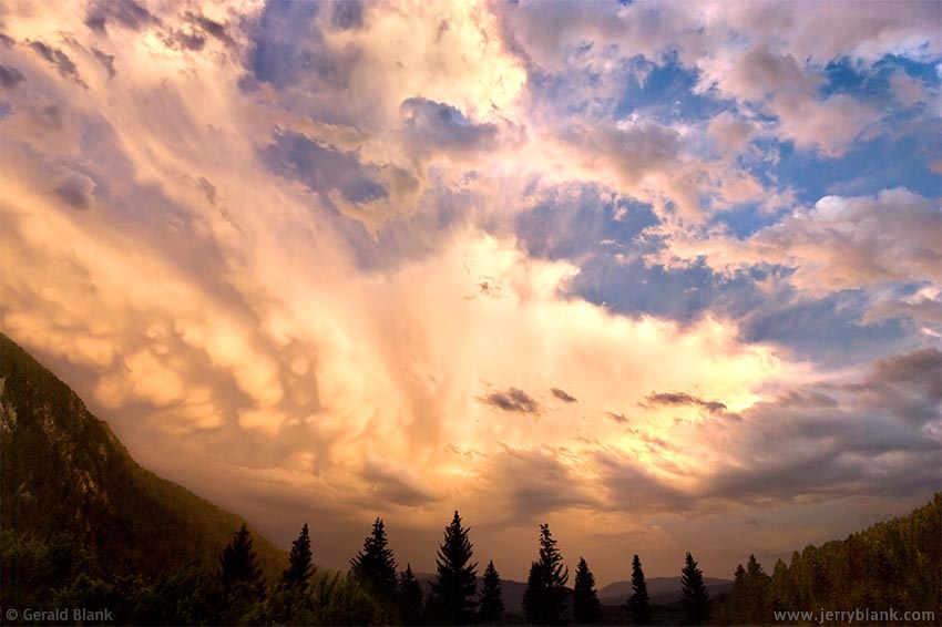
A perfect sunset over the Little Missouri River — Click / tap image to view full size
So I came to its rescue, bracing myself as well as I could on the dusty slope. With both arms free, I was able to reach under the juniper and to gently lift the fawn’s leg up and out of the branches in which it was trapped. Having accomplished that, I scooped it up carefully as I got to my feet, cradling the fawn in my arms like the baby it was. As I climbed toward my car with an armload of baby deer, the fawn bleated loudly for its mom. I’d heard a fawn “calling for Mom” once before! Getting my butt kicked by an angry doe, I decided, would end the day on a sour note. So I said: “Okay, I’ll put you down. Just sit tight for a sec, okay?”
Yeah... right. That adventure ended just like the prairie chick episode: The fawn dashed back down the coulee with amazing speed as soon as its feet touched the ground, and was out of sight by the time I grabbed my camera. But—to look at that glass half full—I soon noticed that the coulee led to another nice view of the Little Missouri River, with interesting weathered sandstone formations and flowering cactus nearby. The day was looking up! An image of that location can be seen above.
It was getting late by this time, and I believed I had enough time to re-visit a spot I had found earlier in the day—a bluff overlooking the Little Missouri—and perhaps get a nice sunset photo. Upon arriving there, I knew I had made the right call. The river, which had looked “flat” in the late morning light, now sparkled and shone with the light of the setting sun, whose glow permeated the leaves of the trees and spread out to the valley below. I got busy and shot photos till the glow was gone and the sun had set.
One of those sunset photos—the image displayed here—was eventually selected for the cover of North Dakota Tourism’s 2009 summer travel guide, and for the cover of the North Dakota Horizons 2009 calendar. As twilight descended upon the Little Missouri National Grasslands, I headed for home with a light heart, but not just because I captured some good images. That afternoon will always be special to me because of the brief experiences I did not record on camera: The prairie chick and the fawn I got to hold for a few moments.
↑ RETURN TO MAIN MENU AT TOP OF PAGE ↑
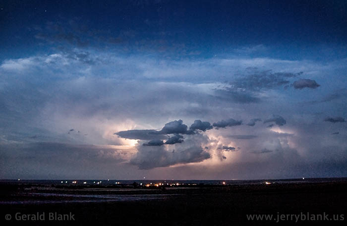
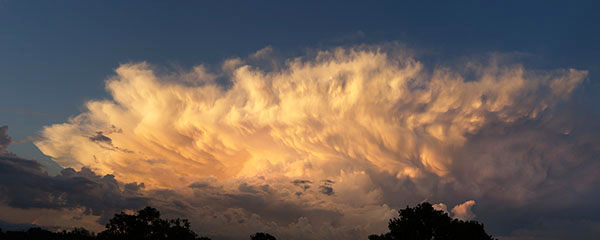
A thunderstorm moves toward eastern Williams County at dusk
The “photo bug” bit me in college, and I’ve been taking photos of North Dakota ever since. In the 1980s and 1990s, I shot photos with a Nikon FE2, an excellent camera body that used 35mm roll film. I still have a few good images from that era, scanned in low resolution, but I didn’t really develop a good photographer’s eye until much later, when digital cameras became affordable. Also, by that time, I was making day trips to the National Grasslands south of the Missouri River, and took fewer pictures close to Williston.
The southern Great Plains is famous for its storms, and for the storm-chasers who follow them with video cameras and other gear. But North Dakota also gets a fair share of photogenic storms in the summer, and I was a bit of a storm-chaser myself. My current home state, Florida, is also stormy, but it’s hard to get a clear view of the horizon because I don’t live on the coast.
North Dakota’s terrain is mostly treeless rolling hills, which makes it easy to chase down a thunderstorm. The one pictured here happened on a warm August evening. I had driven a short way north of Williston to get to a hilltop, from which I took many shots of a storm that was receding to the east as the sun was setting. The lights visible under the clouds are from Carolville, a rural subdivision on County Road 9.
As night approached, I noticed another storm cell coming toward me over the western horizon. It seemed to be a good distance away, perhaps as far as the Montana border, and I hoped it would move toward my hilltop so I wouldn’t have to jump into the car and chase it southward. I could see plenty of lightning on the horizon, but could hear no thunder.
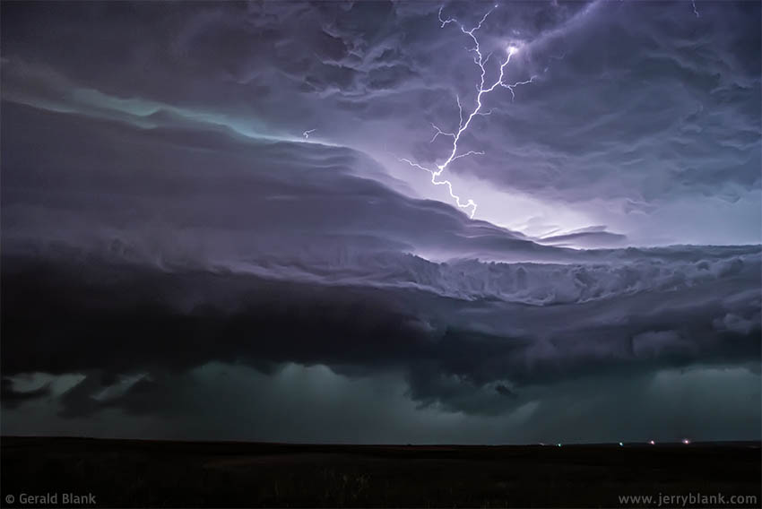
Storm chasing north of Williston — Click / tap image to view full size
As it happened, there was no need to go anywhere; the storm front was moving directly toward Williston. Before long, I was able to get lightning images that filled the frame of my camera. I turned on my camera’s self timer, and set the shutter speed for 10 seconds. By that time, I could hear thunderclaps following the larger bolts of lightning.
I was getting my 10-second image captures at intervals of about 20 seconds, and had just gotten my hundredth exposure when a stiff warm breeze began stirring the grass at my feet. I captured a few more shots, glancing at my car which was parked near the highway 500 feet behind me, and wondering how fast I could sprint back to it with my camera gear in hand.
I was given little time to wonder. A cold, hard gust of wind hit—the outer edge of the storm’s downdraft—and a few large raindrops began to fall. I knew my time was up, scooped up my camera and tripod, and began my sprint to the SUV. By the time I had tossed my gear into the back and jumped into the front of the car, my lungs were burning, the rain was falling harder, and the wind was whipping loose dirt into the air.
Shortly after I slammed the car door shut, all hell broke loose outside. The gusts were now picking up large grains of sand, but the gusty sandblast was soon subdued by the torrential rainfall which followed. Outside my car, it seemed everything was lightning, thunder, and rain. I could feel the SUV sway with each gust of wind.
Meanwhile, my breathing returned to normal. I wiped the raindrops off my eyeglasses, took the camera off the tripod, switched on its preview screen, and examined the results of my evening’s adventure. Happily, as I’d hoped for, several good shots were sprinkled among the other images of dark clouds. The “lit up” images clearly showed the roiling storm clouds and the dense bands of rainfall.
Pre-dawn light reflected in the Little Muddy River, east of Williston
The following month, I started exploring the fall scenery south of the Missouri River, in McKenzie and Billings counties. On Sept. 10, the day of my first fall trip, I left my house before dawn, intending to get to my destination while it was still early in the morning. When I walked out of my front door, the pre-dawn sunlight had set the light wisps of cloud cover on fire, as you can see in this photo. This shot took some quick thinking, because my house in Williston didn’t have a clear view of the horizon.
I remembered the one spot within a mile of my house that did have a clear view eastward; it was where County Road 7 ends at the shoreline of the Little Muddy River. With no other cars on the highway, it only took me a few minutes to get to that spot. The light in the eastern sky remained good for another few minutes, which was a lucky thing. Past experience has taught me that such moments of pre-sunrise and post-sunset flourescent color don’t happen every day—and when they do happen, they only last minutes—so one must act quickly to capture them.
When the glow faded, I took to the road as planned, but the light wisps of cloud began to thicken, and it was pretty much overcast for the remainder of the day. I successfully scouted out some photogenic areas of the Badlands for my next trip. But as I told my family and friends afterward, the pre-dawn photo I captured by the river was my only “keeper” of the day. Had I known beforehand how cloudy it would be that day, I would have returned home and gone back to bed instead of going on a long excursion through the Badlands!
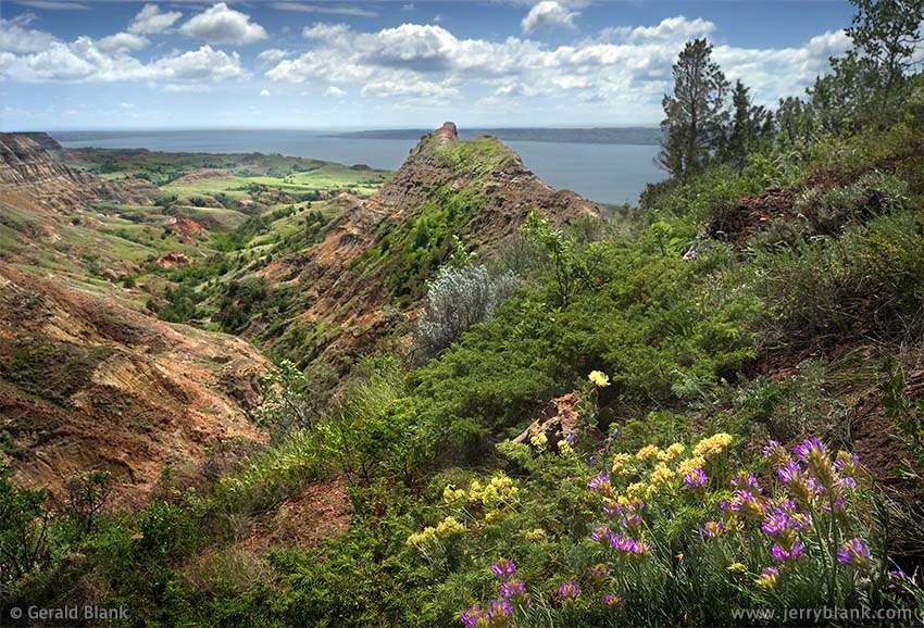
A view of Lake Sakakawea from the bluffs — Click / tap image to view full size
Along the Missouri River, there is rugged terrain similar to the Badlands, featuring eroded clay bluffs with bands of red scoria and streaks of lignite coal. McKenzie County, on the south side of the river, features more of that terrain than Williams County, but the north side of the river does have some of the same scenic shoreline terrain, which hosts a wide variety of wildlife.
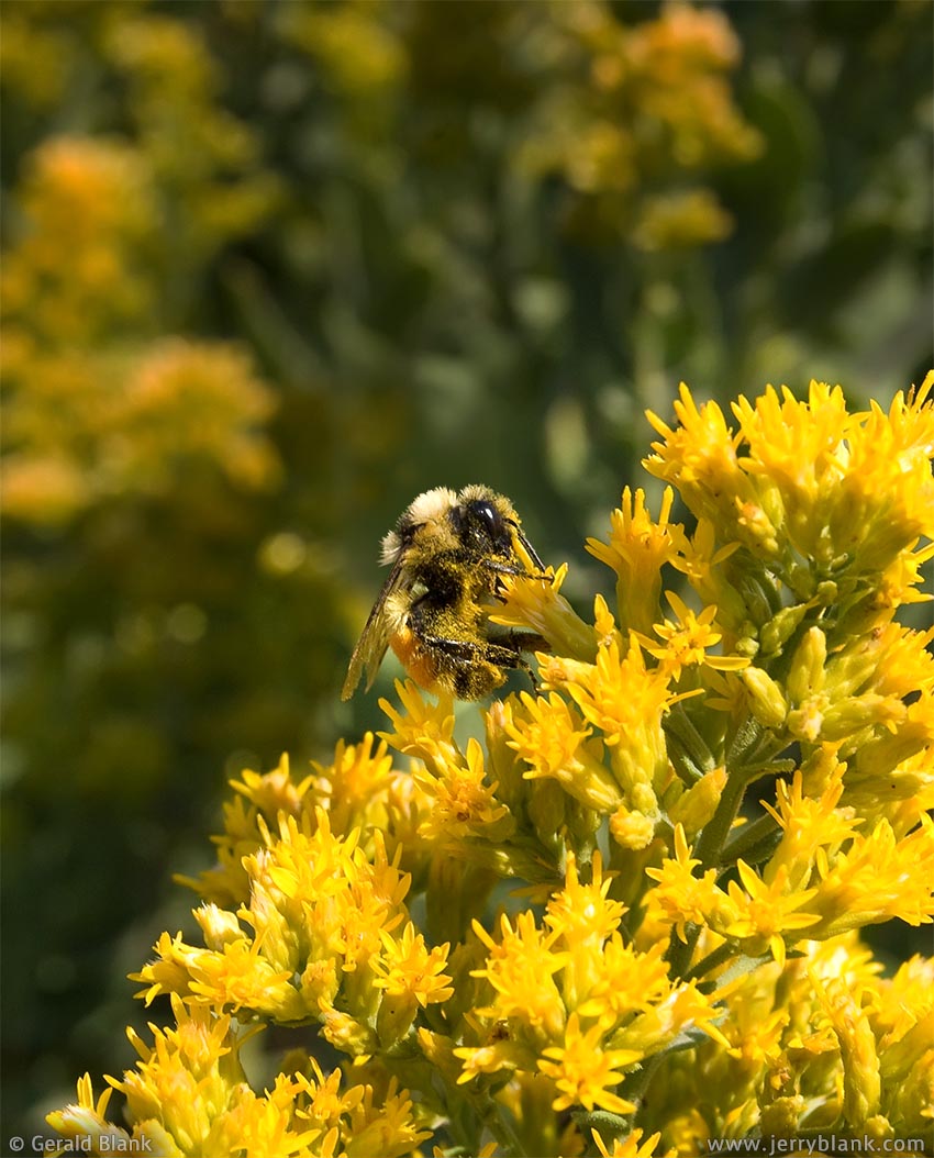
A bumblebee visits a goldenrod patch near Williston — Click / tap image to view full size
A fine example of that terrain is pictured here. This photo was taken during a hike in the bluffs near Hofflund State Game Management Area. If you follow the link or check out the location on Google Maps’ “Earth” view, you’ll see some oil well pads along the riverside and a reddish open pit scoria mine. On one trip to the riverside, I parked my SUV along a nearby public access gravel road and hiked to the spot pictured here, which has a great southeast view past the bluffs and over Lake Sakakawea, the Missouri River reservoir above Garrison Dam.
My favorite time of year for hiking these areas was late in June to early July, depending upon the timing of the spring rains and the arrival of warm weather. In the northern tier states, there isn’t really a spring wildflower season; most of the color happens at the beginning of summer. On June 28, the day this image was captured, it was pretty darn colorful, with all the wildflowers, juniper and cedar foliage, and the grassy hills in the background.
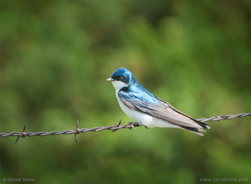
A tree swallow perches on a fence at Lund’s Landing, near Lake Sakakawea — Click / tap image to view full size
By August, North Dakota typically gets hot and dry, and scenes such as this one lose much of their color and turn brown. By mid-September, though, some of the color returns, as the trees begin changing color and large yellow patches of goldenrod and rabbitbrush make their appearance. There are more wildlfowers to see if there are fall rainshowers, and if the first hard frost doesn’t come early. Such was the case in 2007, when I captured a photo of a bumblebee visiting a goldenrod patch near my house (displayed above).
A few miles upstream from Hofflund Bay is Whitetail Bay, a popular summertime recreation spot for folks in Williston and Williams County. Years ago, there was a small marina, lodge, and restaurant perched on a hillside on the west side of the bay. Jim and Analene Torgerson managed the marina, named Lund’s Landing, for many years.
When I lived in Williston, we would sometimes drive out to their cafe for dinner, and chat with them about what new feature they’d added to the place that season.
One thing the Torgersons did early on was to build many bird nesting boxes on the fenceposts in and around their property. This has attracted a large number of brightly colored tree swallows (often mis-identified as mountain bluebirds) during the warm season, which are fun to watch. In 2008 I spent an entire morning just taking bird photos, a couple of which I’ve shared here. I discovered that many yellow-headed blackbirds make their home in the wetlands around the marina.
It’s been many years since I visited Whitetail Bay, but I hope the blue tree swallows still return to the hillside east of the bay every summer!
↑ RETURN TO MAIN MENU AT TOP OF PAGE ↑
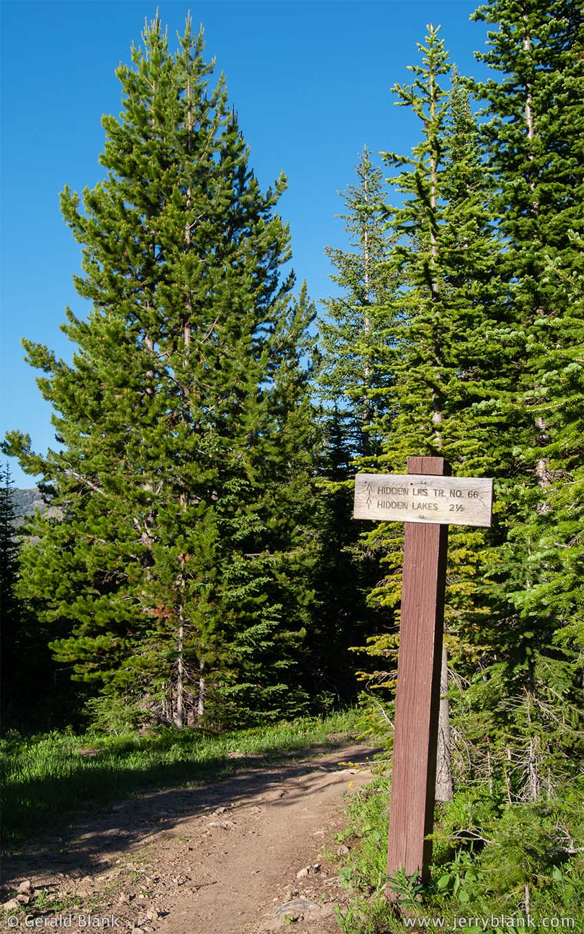
Sign at Hidden Lakes trailhead
In the summer of 2008, I decided to visit some of the “hidden” lakes of southwestern Montana. My definition of a “hidden” mountain lake is one that is not a typical summer destination. The lakes I’ve visited can be accessed via Forest Service trailheads and “easy” to “moderate” hikes, but can’t be seen from any highway.
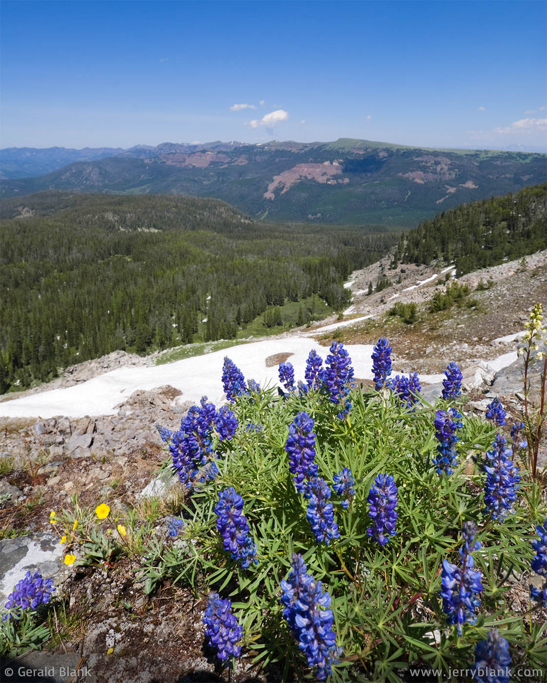
Lupines growing at the top of the ridge, north of the lakes
The Hidden Lakes Trail, south of Bozeman, Montana and east of Big Sky, leads to a small chain of lakes at the base of a ridge at the northwest end of the Gallatin Range. The largest and highest lake is the “official” Hidden Lake, at 9,033 feet—about 850 feet above the trailhead and about three miles in. These lakes are not stocked, but there are golden trout in at least a couple of them.
To get to Hidden Lakes via US Highway 191, look for the Portal Creek Road 984 sign between mileposts 53 and 54. The sign facing the southbound lane is much more obvious than the one facing traffic coming north from Big Sky. The exit is on the east side.
The Hidden Lakes trailhead is about six miles from the highway, via Portal Creek Road. About halfway in, the road forks and a Forest Service sign indicates the correct route to the Hidden Lakes trailhead. Trail #66 is a pretty straightforward hike—steeper for the first mile, then giving way to a more comfortable mix of uphill and downhill.
One of the great views from the high ridge. This is a view of Cedar Mountain and Lone Mountain.
The only tricky part is where the trail forks, about a mile and a half from the trailhead. There is no sign at the fork. The left fork is the continuation of Trail #66, and leads the hiker to a ridge ending on the south side of the highest lake, but this route bypasses the other lakes. The right fork, Trail #179, is probably the one you’ll want to follow, as it leads directly to the lower “Hidden Lakes” in the chain. From there you can follow the trail to the higher lakes, and finally to the “official” Hidden Lake, the highest lake in the chain.
The view to Hidden Lake, looking southwest from the ridge
Hidden Lake is a beautiful blue lake in an equally beautiful setting: A bowl enclosed on the south by a high rocky ridge, and on the north by spruce. Casual climbers (or serious hikers) can hike to the west side of the lake and up the ridge, whose highest elevation is about 800 feet above the lake. It’s a steep slope, but not dangerous if the weather is clear and you’re careful. Those who make the effort are rewarded at the top with clear views of the Gallatin Range, the Spanish Peaks, and the Madison Range. Many of the evergreens on this ridge are twisted and bent in interesting shapes by the high winds.
Depending upon the season, you may also find plenty of subalpine wildflowers on the crest of the ridge. If you do as I did, you may capture decent wildflower images at midday. However, the best shots are normally captured just after sunrise and just prior to sunset.
Whether you choose a sunrise or sunset time is up to you, because there are multiple backdrops to choose from. The first image of lupines in this post was captured facing northeast, between Windy Pass and Eaglehead Mountain.
In the opposite direction, you can shoot west toward Big Sky, and get Cedar Mountain and Lone Mountain in the background. With a little hiking around, you can get fine vantage points southwest toward the Spanish Peaks.
There are no developed camping facilities at Hidden Lakes, but there are are good spots to pitch a tent just about anywhere. At Hidden Lake, the elevation rises quickly as one moves away from the lake; you can camp on high ground and stay in the shade. There isn’t much unpleasant undergrowth to deal with, because this location happens to have older spruce and fir tree cover.
The ridge blocks the nighttime glare east from Big Sky, so overnighters will have plenty of stars to gaze at. An added bonus is the peace and quiet. The dust and noise of a busy campground road is not part of the Hidden Lakes experience. On a busy evening, campers may see the smoke of one or two other campfires in the distance.
↑ RETURN TO MAIN MENU AT TOP OF PAGE ↑
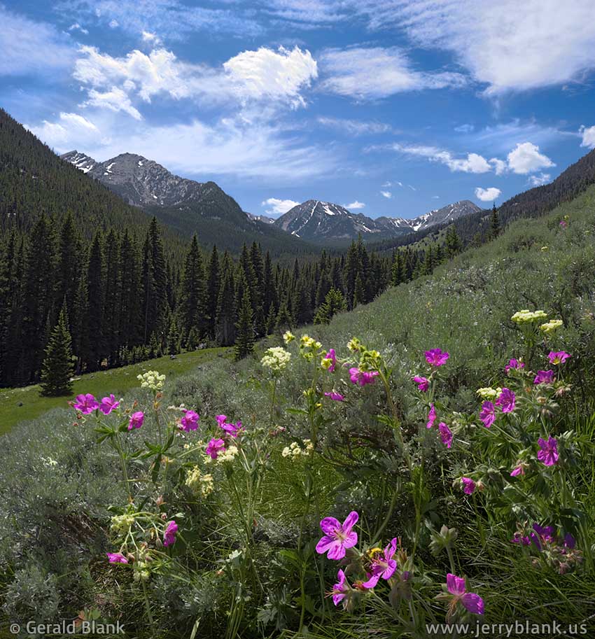
Wildflowers in the South Boulder canyon
In the blog entry above this one, I mentioned my journeys to some of the “hidden” lakes of Montana’s Gallatin Range. The lakes I’ve visited can be accessed via Forest Service trailheads and “easy” to “moderate” hikes, but can’t be seen from any highway.
Nestled deep in Montana’s Tobacco Root Mountains are many such lakes, some of which are easily reached from the South Boulder River access road in the Beaverhead–Deerlodge National Forest.
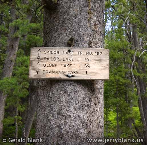
The Sailor Lake trailhead
To reach the USFS access road, one needs to get onto Montana Hwy. 359, which can be accessed from the north via the Interstate 90 exit at Cardwell, or from the south via US 287 near Harrison. The South Boulder road exits MT 359 on the west, and makes a lot of twists and turns past farms and ranches before following the river southwest into a picturesque canyon. During the summer, brightly colored wildflowers are plentiful in the open sunny slopes of the canyon, as one can see in the picture shown here.
The lower South Boulder canyon is a nice drive in itself, featuring a wide variety of scenery. About halfway in is a village of cabins straddling Park Creek, called “Mammoth”. Continuing on to the southwest, on the left side of the road, is a trailhead which provides hiking access south toward Louise Lake.
A half mile past the Louise Lake trailhead, the main road ends at a fork. The right fork is a two-track road, which is best navigated by high-clearance 4WD vehicles, or better yet, ATVs; it hasn’t been maintained by the Forest Service since the mining and logging days of the 20th century. About 18.7 miles from MT 359, the two-track road (if it can still be called a road) dead-ends at a small campsite, an ancient rusty piece of mining equipment, and the Trail #167 trailhead.
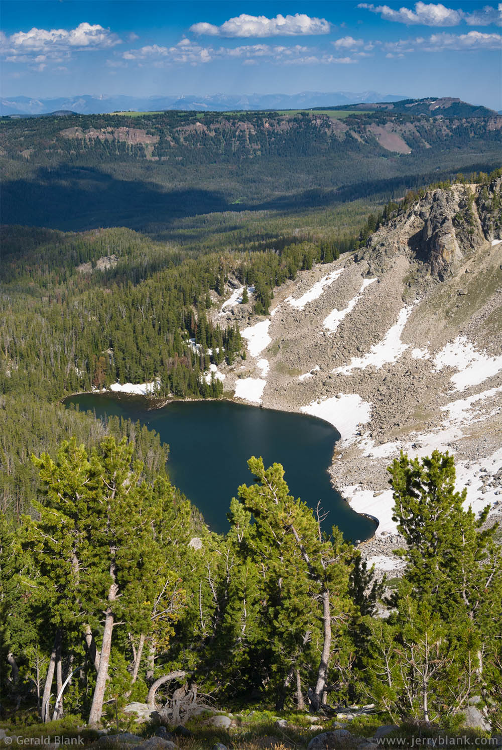
An excellent morning above Sailor Lake — Click / tap image to view full size
From this trailhead, there is relatively easy access to Sailor Lake, Globe Lake, and Brannan Lakes. Although (as of 2009) the trailhead sign gives the distance to Brannan “Lake”, Google Maps clearly shows Brannan Lakes as a higher chain of shallow lakes. At the outlet of the lowest Brannan Lake, the South Boulder splashes merrily down a rocky cascading slope into Sailor Lake.
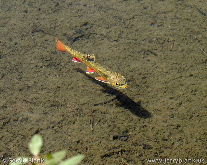
Brook trout in the shallows of Globe Lake
Sailor Lake is the first stop on Trail #167, a pleasant uphill hike of about half a mile. When I followed this route and arrived at Sailor Lake, I hiked around to the inlet of the lake on the far shore. The steep slope where the cascade splashes into Sailor Lake has a great south view of the Lake and the surrounding peaks of the Tobacco Root Mountains. As nice a spot as this is, I was a little surprised I saw only a few other visitors. Most of the people I had seen to this point were anglers parked along the South Boulder River a few miles down the canyon, where it’s a swiftly-flowing mountain creek. Up at the outlet of Sailor Lake, the South Boulder is little more than a babbling brook.
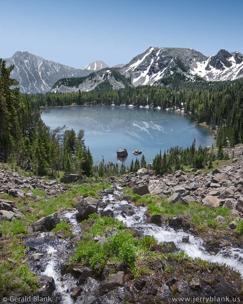
Next, I retraced my steps along the shoreline and followed the last quarter mile of the trail to Globe Lake. Globe Lake is a little smaller than Sailor Lake, but otherwise similar; another beautiful and secluded spot. Walking around the lake, I noticed it is well stocked with brook trout.
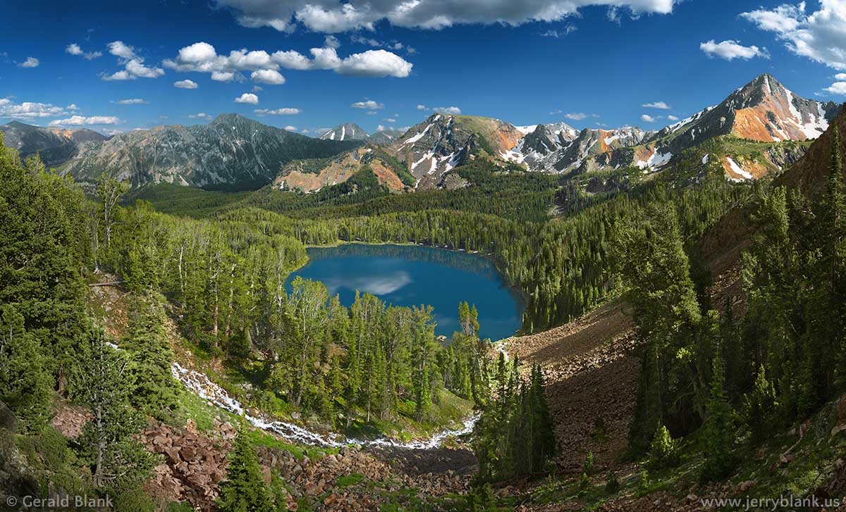
The higher view of Sailor Lake is better — Click / tap image to view full size
I was pleased with the scenic images I’d captured, enough so to make a second visit the following summer of 2009, and to hike up the extra half-mile to explore the Brannan Lakes. Nestled in a cirque beneath an un-named peak, these ponds are the essence of what “getting away from it all” means in Montana. The south rim of the cirque offers grander view of Sailor Lake and the South Boulder River canyon far beyond—a better panoramic view than I could get from the bottom of the cascade on my previous visit.
In early summer, the Brannan Lakes are filled with snowmelt from the mountains towering above, and the cirque is lush, green, and dotted with wildflowers. The only disadvantage of visiting in that season is that the moist, boggy slopes are perfect mosquito breeding grounds... so campers are more likely to be eaten by insects than by bears, unless one’s tent has mosquito netting. Sometimes you gotta take the bad with the good!
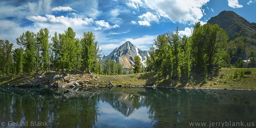
Mount Jackson reflected in one of the Brannan Lakes
Another word of caution: At the time I lived in Montana, the Beaverhead-Deerlodge National Forest had been hit hard by the mountain pine beetle. Evergreen trees that have been killed by the bark-burrowing insects have green needles during an infestation, and typically into the following winter. But when the snow melts and the forest comes out of dormancy, the dry foliage suddenly dies, turns reddish-brown, and becomes the ideal fuel for forest fires.
Some folks don’t mind the aesthetics of reddish foliage, but I think that color looks nicer on the autumn leaves of scrub oak. But this is the 21st century, and coloring is a minor issue. I usually use Photoshop to change reddish evergreen needles back to a more lively green color.
The major issue for hikers, anglers, and campers is one of safety. The South Boulder canyon may now be at the end stage of the pine beetle infestation, but there are now many standing beetle-killed trees, which can fall without warning onto the two-track road or the hiking trail. Motorists may need to bring a chain saw, and hiking with at least one partner is prudent. In rare cases, the Forest Service will post tree-fall warning signs at trailheads—but do yourself a favor, and use your own eyes and ears when hiking through areas of dead timber!
↑ RETURN TO MAIN MENU AT TOP OF PAGE ↑
A Florida thunderstorm, just after sunset
Soon after moving to central Florida, I noticed that summer thunderstorms pop up nearly every afternoon, only to mellow out toward the end of the day when the sun’s energy subsides and the air currents become calmer.
On one such day late in May, the weather in northwestern Orange County was fair, but I could see plenty of action in the northern skies as the day wore on. I came home, had supper, and stretched out on the couch for a while till close to sundown, when I noticed a peach-colored glow through my picture window. Grabbing my camera and quickly checking its settings, I rushed outside to see, literally, what was up.
The weather system I noticed hours earlier had moved east—out toward Daytona Beach or beyond, from what I could tell—and the last few rays of sunlight set the clouds ablaze in brilliant colors. This was one of those “right place at the right time” opportunities, and the image tones needed little adjustment. What you see here is pretty much what I saw.
Montana storm clouds, just after sunset — Click / tap image to view full size
The second image in this post was taken a few years earlier, in the summer of 2008, during a trip to Madison County, Montana. On that photo safari, I had a rare opportunity to explore restricted-access private and Forest Service lands on Fan Mountain, just west of Big Sky. It was great fun and I captured many nice images. I could see a thunderstorm gathering, but it was way off to the southeast, beyond Lone Mountain and Big Sky, and looked to be heading towards Yellowstone. So I continued exploring the area until close to sunset. The storm receded into the distance, and was soon forgotten.
Toward evening the slopes of Fan Mountain began to fade into shadow. I figured I was done playing for that day, and headed toward Big Sky, about a half hour to the east. The sun had not quite set by the time the road opened into the meadows of the Gallatin Canyon, but everything below the horizon was nearly dark.
Having gotten stiff and thirsty, I pulled off the road into the parking lot of a Big Sky convenience store, and stretched my legs. Just south of the gas station, on US Hwy. 191, is a local landmark called Soldier’s Chapel, a place with tall evergreen trees along its fenceline. A peach-colored glow caused me to look up over the trees. The remnants of the storm I had spotted earlier were now right above my head, brightly lit by the setting sun, and the contrasts of color, light, and shadow were incredible!
The next half-minute was a blur, but I’m certain I set a personal speed record for unpacking my camera, mounting it to its tripod, and getting back to my vantage point near Soldier’s Chapel. Other travelers milled about in the parking lot behind the gas station—all with faces turned skyward, all just as awestruck as I was.
While I like both these photos, there was something special about those few minutes shared with travelers years ago, in a Big Sky parking lot. For me, it was a reminder of my good fortune to have been born and raised in the USA. And therefore—as night fell and I approached my car to leave—I looked up one more time, and said “Thank you”.
↑ RETURN TO MAIN MENU AT TOP OF PAGE ↑
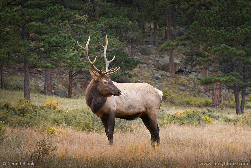
I recall that the first full day I ever spent in Colorado was late in 2008, and the place was Rocky Mountain National Park. I arose before dawn that morning to explore the fall foliage around Alberta Falls in Glacier Gorge, and my route led me out of Estes Park and through Moraine Park.
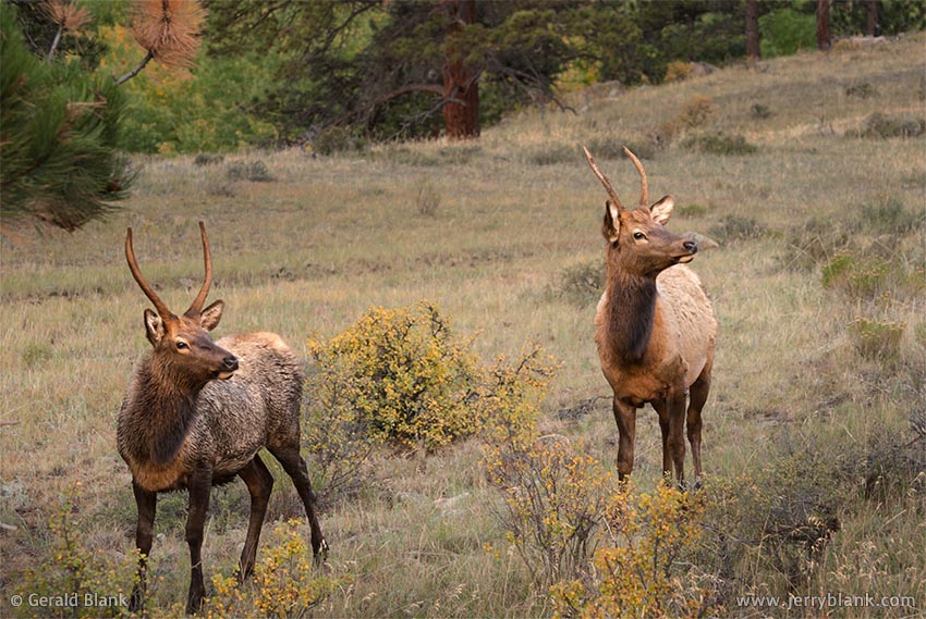
An alert pair of juvenile elk —
Click / tap image to view full size
I had barely entered Moraine Park when I observed that I was practically surrounded by elk. At the time, that seemed impressive. There are many deer and antelope in the Northern Plains states, but far fewer elk. The only ones I had seen before were in a hunting preserve. Fortunately for them, I only hunt with my camera.
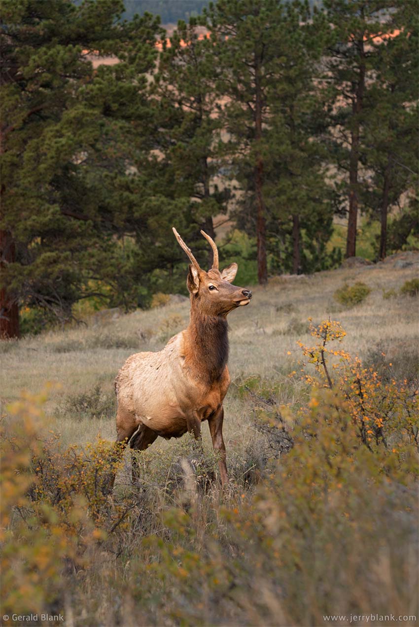
Young bull elk —
Click / tap image to view full size
I had also seen elk in the wild while hiking in Montana, but they were very skittish, and did not hang around to have their picture taken.
The elk in Rocky Mountain National Park, though, have seen so many two-legged gawkers in their range that they didn’t pay much attention to me. In spite of my enthusiasm, I had the wits to close my car door quietly and to approach the animals very slowly.
I had my telephoto zoom mounted to my camera, of course. The sun had risen, but the light in the canyon was still dim and I had to shoot with the lens wide open to get an image that wasn’t blurred. Surprisingly, I didn’t have to zoom the lens all the way out on any of these pictures... that gives you an idea of how close I was able to get.
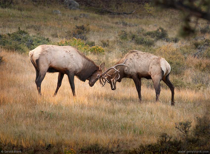
Bull elk locking antlers — Click / tap image to view full size
As you can see in every image, they had me in the corner of their eye, but their attention was directed elsewhere.
At the time, I had no idea why so many of them were gathered near Estes Park. More recently, I learned that Rocky Mountain National Park is their seasonal migration route. They damage aspen stands in their search for food, to the dismay of environmentalists.
The local beavers are also dismayed during the season, since the elk snarf up much of the food the beavers need to get through a winter in the Rockies. Many other mountain critters—including elk—have the same idea; the elk are only trying to make a life for themselves. Over the years, more and more people have been moving into the Front Range mountains surrounding the park. So if Nature seems unbalanced, one can thank the two-legged folk; we have way more freedom of choice than our wild neighbors.
The victorious bull — Click / tap image to view full size
That morning, though, the only thing I saw through my camera lens was nature in balance, and it looked great. I saw young bulls with small antlers just losing their velvet. A couple of them engaged in playful sparring, but I could tell there wasn’t much aggression in their sport. They were instinctively playing out the mating competition that would come when they were mature bulls.
I returned to my car and headed to the Moraine Park visitor center, thinking to answer the call of nature before heading into Glacier Gorge.
Unfortunately, I had arrived too early; the visitor center was still closed. Fortunately, there were a pair of bull elk near at hand—so close that any fool with a camera could get great shots. Unfortunately, if they chose to vent their aggression upon me, I’D be the fool; my back was against a locked restroom door.
But, like all the other elk, they pretended I wasn’t there. They were more interested in locking antlers with each other. Unlike the juvenile bulls, these two were playing for keeps. The one pictured at left had an uphill advantage, in addition to a few more pounds and a larger rack of antlers than his rival on the right. So the right elk gave up in a few minutes, and walked away from the visitor center calmly, no doubt wanting to show at least a little dignity.
After that, I had the victorious elk to myself. Or he had me to himself. I couldn’t be sure. As he surveyed his territory, I captured perhaps a dozen more shots before deciding to leave. The bull found that arrangement acceptable... but as I walked around to the parking lot, we didn’t take our eyes off one another.
↑ RETURN TO MAIN MENU AT TOP OF PAGE ↑
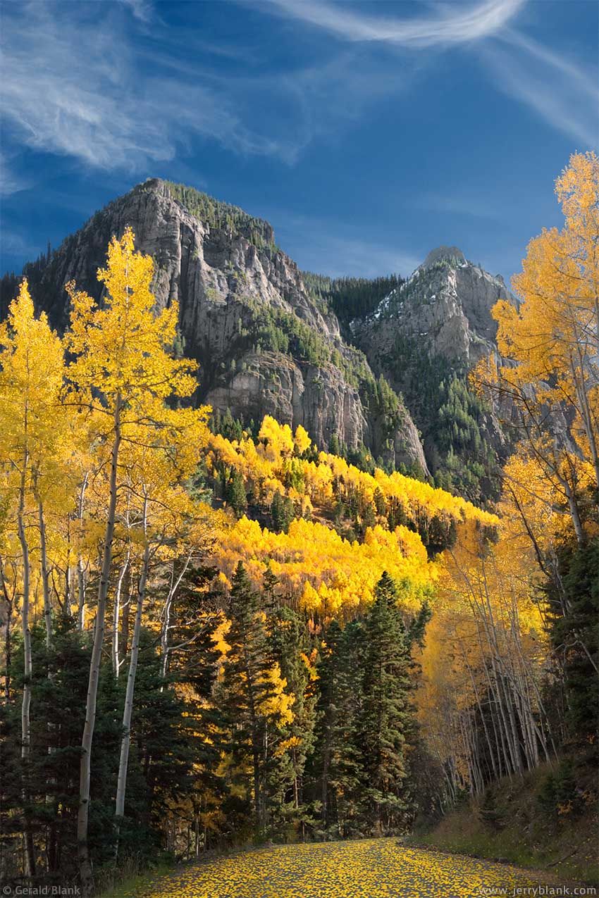
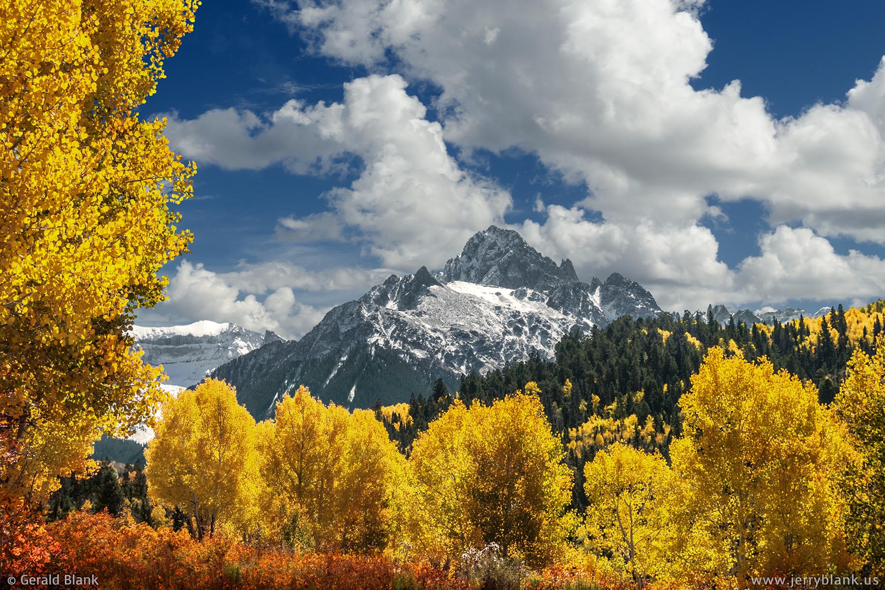
By 2008, I was pretty familiar with the northern Rockies, and in fact I moved there toward the end of that year. I had never visited the Rockies south of Montana, but had learned of the great autumn scenery in the Colorado Rockies. Aspens can be found everywhere in the Rockies, but it just so happens that Colorado has a “sweet spot” environment for aspen growth. In Montana, trees with color are more sparse. An early freeze in the north often cuts the fall foliage display short.
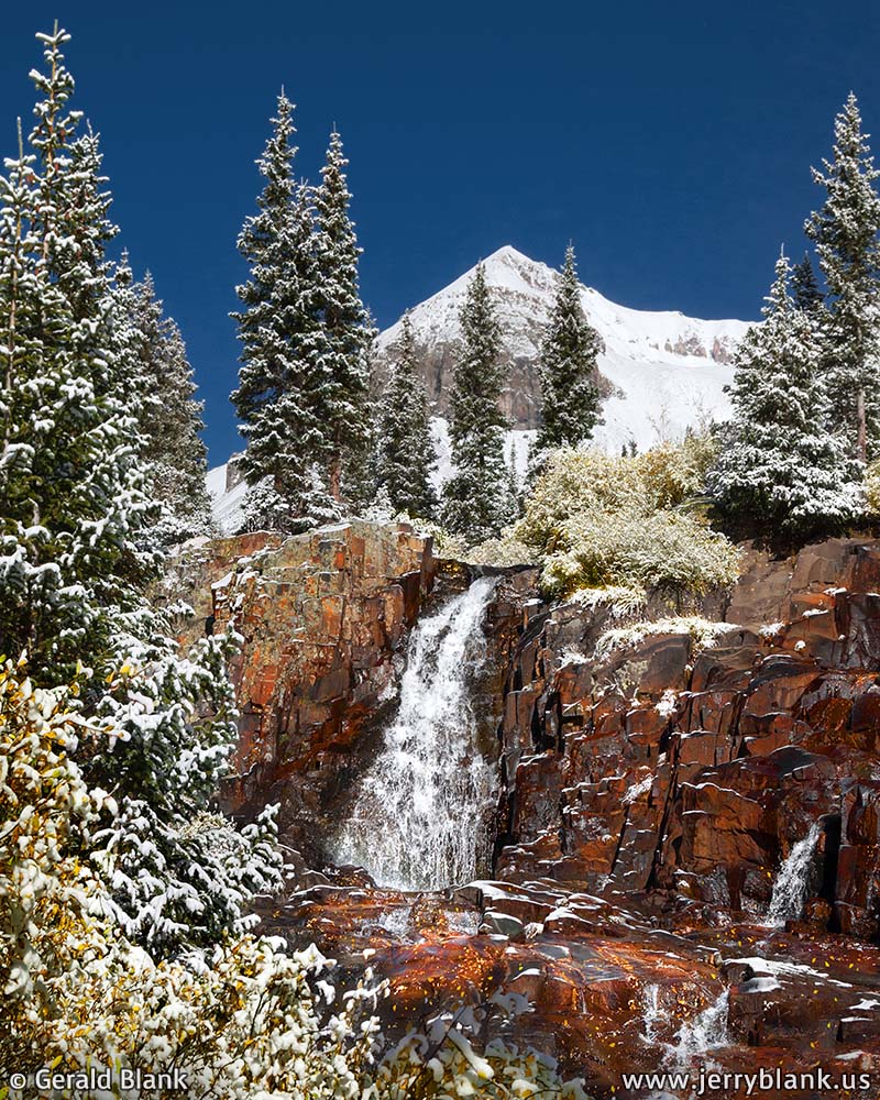
Fresh snow at Yankee Boy Basin — Click / tap image to view full size
Rocky Mountain National Park and the Maroon Bells were my first stops during my 2008 trip to Colorado. But that season, the fall colors came and went early in the northern part of the state—they had peaked before the end of September. I did capture some great wildlife images near Estes Park, but was a bit dismayed by the sight of bare aspen trees.
I was aware that winter cold comes to southwestern Colorado a little later in the season, and that photographers often travel to the San Juan Mountains to find autumn color. So I decided to try my luck there, and to begin by staying in Ouray for a few nights.
The day I arrived at the San Juans, I had seen mixed sunshine and occasional rain—but when I got closer to the mountains, I could see that the skies over the mountains were shrouded by black. The weather report for the days ahead was encouraging, though, so I drove into the rain and through Ouray, found my way to Canyon Creek Road #361, and followed it up the canyon a few miles to the Thistledown campground in the Uncompahgre National Forest.
The campground was deserted because of the weather. It was nearly dark, but in spite of the low light and the rainfall, I fell in love with the spot at once. The burbling creek coursed right past my parking spot, and gold aspen leaves fluttered gently in the wind. It did not take long to fall asleep.
As I slept, colder air moved in... and when I awakened, I could see a light dusting of snow on the campground. Looking past the aspens toward the sky, I observed that the cloud cover was beginning to break up, so with renewed enthusiasm, I freshened up, ate breakfast, and drove back onto Canyon Creek Road, wondering what I would see at the higher elevations.
I wasn’t left wondering for long. In only two miles, I reached an elevation where everything was covered in snow. I was in the midst of a winter wonderland, but autumn was far from over; the golden leaves of the aspen trees were covered in heavy wet snow, and their branches sagged under the added weight.
The Forest Service route is also called “Camp Bird Road” because it ends at Camp Bird, an old mining site. From there, one can turn south on route 26A and travel by Jeep over Imogene Pass to Telluride—but I was not about to attempt such a thing in the snow with my SUV. Turning west onto route 26 instead, I headed toward Yankee Boy Basin, a cirque which is surrounded by the high peaks of the Sneffels Range.
An amazing view of Hayden Mountain South —
Click image to view in full size
The road was safe enough, but soon became too steep for my SUV to climb, so I parked the car and hiked up toward Yankee Boy Basin. In minutes, I found the scene pictured above: The clear icy water of Sneffels Creek, which cascaded over reddish rocks past snow-covered foliage.
I was, as you may imagine, in photographers’ heaven, and would have loved to spend more time exploring the falls, but the sun was beginning to work on the snow. So, instead of exploring the higher altitudes—which have few trees anyway—I drove back down past Camp Bird. At that point, I was greeted by an amazing panorama of Hayden Mountain South, framed in snow-covered aspen trees which were set on fire with sunlight.
The snow was melting quickly under the warm sun, so I continued taking pictures all the way back down Canyon Creek Road. By the time I arrived in Ouray for lunch, the snow was off the trees...and by sunset, it had receded nearly up to the treeline of the mountains. But the peaks themselves would remain snow-capped for the next few days. Just about everywhere I explored that week, there was excellent scenery to be found.
While it helps to plan one’s trips around the weather, one should still expect the unexpected, and be prepared to roll with it. I get off the highway as much as possible, for it is on the Forest Service roads and foot trails that I discover the hidden gems of the Colorado landscape!
↑ RETURN TO MAIN MENU AT TOP OF PAGE ↑
Looking over Ouray toward Twin Peaks —
Click image to view in full size
In the post above, I shared the stories and photos of the first morning I explored the area near Ouray, Colorado. As the morning grew late, the sun began to gently pull the clouds skyward, away from the mountaintops. Finally, I quit taking photos and returned to town for lunch.
That afternoon, I hiked the Ouray Perimeter Trail, which you can see here on Google Maps if you happen to find yourself in Ouray in the future (and I certainly hope you do!). In the photo displayed here, I was looking over the southwest corner of town, toward the entrance to the Uncompahgre Gorge.
The view on Canyon Creek Road — Click / tap image to view full size
Because of the previous night’s snowfall, some of the rock formations overlooking Ouray were still wet, and looked dark red from my vantage point. And as you can see, many other colors were splashed upon the lower slopes of Mount Abrams and Hayden Mountain South.
The trees in the foreground of this picture are scrub oak, a common sight in the lower elevations of Colorado mountain country. In autumn, their color can change much like their neighbors, the aspen, except that the warmest color scrub oaks display is a reddish orange. In isolated stands of aspen, the leaves will get all the way to red before dropping.
After spending another peaceful night at the Thistledown campground on Canyon Creek Road, I drove to Ridgway, a short distance north of Ouray on US Highway 550, to explore the fine Colorado scenery in the Sneffels Range, which is practically in Ridgway’s back yard. I could have spent that night west of Ridgway, at a campground not far from Dallas Peak, but returned to Thistledown instead. I had grown to love the sound of the burbling water of Canyon Creek, which rushes right past the campground on its way to the Uncompahgre River gorge.
By that time, it was late afternoon, and the low western sun was catching the leaves of golden aspen stands hugging the north ridge of Hayden Mountain. With scenery such as that pictured here, I could hardly be blamed if I chose to make the canyon my home forever. Alas, autumn in the high country comes and goes quickly. Unlike the black bears, I am unable to sleep through the winter. Nevertheless, I thought myself a lucky man to be able to stay at the place for a few nights.
I could hardly do justice to the scenery around Ouray with my camera—but I did my best, hoping the images I have shared will inspire you to visit Ouray during the fall color season. While Yankee Boy Basin and other high altitude areas near Ouray have excellent wildflower displays going on in August, the San Juans are a much more peaceful place to visit in the fall months—after the crowds of summer vacationers have left, and before skiers begin flocking to Telluride.
↑ RETURN TO MAIN MENU AT TOP OF PAGE ↑
To continue from the posts above, about my autumn trip via US Highway 550 to Ouray, Colorado: The town extends to the south end of the narrow box canyon in which it lies. At that point, the highway and the Uncompahgre River enter the canyon and continue on to Ouray and Ridgway.
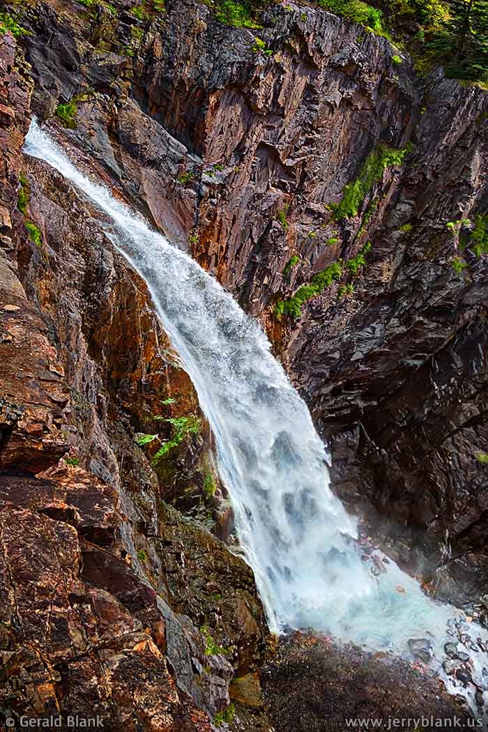
Waterfall on Bear Creek — Click / tap image to view full size
The first attraction for southward travelers is Bear Creek Falls, not quite three miles south of Ouray. On the west side of the highway, the waters of Bear Creek fling themselves under the highway bridge, over a ledge, and into a narrow, deep chasm with a turquoise-colored pool at the bottom.
There are plenty of vantage points from which one can admire the falls. I spoke with one such admirer, who informed me that if I returned to the gorge in early summer, the waterfall would be more impressive to look at. That seemed to make sense, but something compelled me to stay a while and capture a series of images anyway. Waterfalls—like people—each have a unique character. Just as you and I can experience different moods, a waterfall’s “personality” changes with every season... and with every change in ambient lighting.
After writing my previous blog entry, I was sifting through my folder of images of Bear Creek Falls and came across the one I have posted at left. I realized what compelled me to capture the images and to hang on to them all these years. I recall that when I visited the falls, the water appeared to flow in an unbroken ribbon... but my camera had captured an image of the the water in 1/320 second. Seen in this brief slice of time, the falls are more three-dimensional. The water forms a delicate arched shape, which repeats itself until it meets the pool.
Farther up the highway, the Uncompahgre River cuts through Poughkeepsie Gulch before crossing beneath the road and splashing its way down Uncompahgre Gorge. The road to Engineer Pass follows Poughkeepsie Gulch eastward at a fairly steep ascent, but I figured there was little risk in navigating it with my SUV, and decided to give it a try.
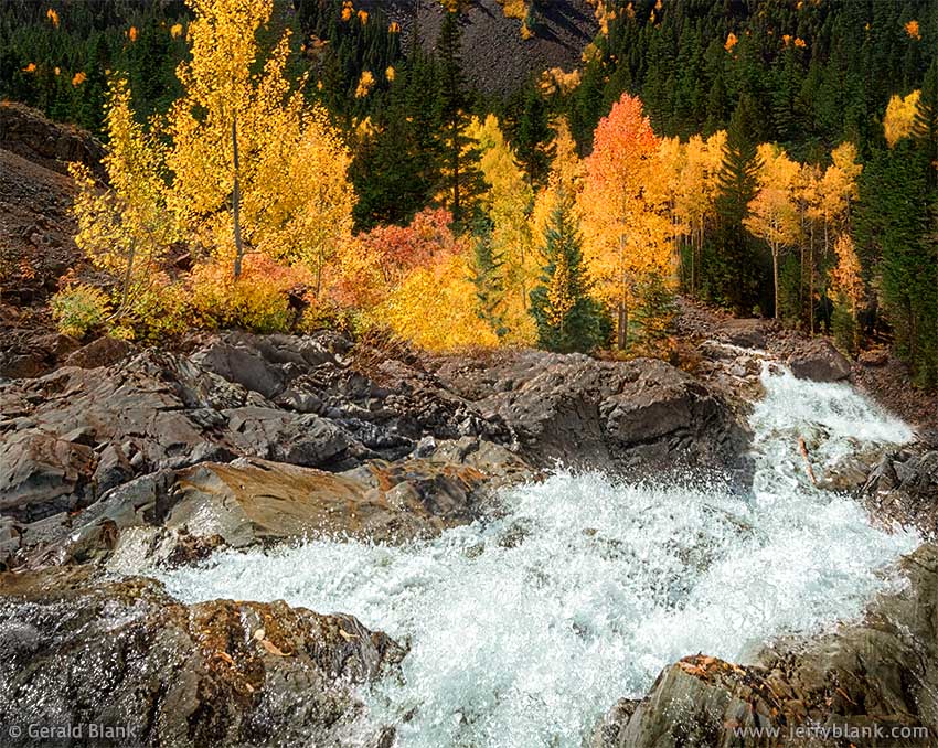
Autumn colors at the Uncompahgre Gorge — Click / tap image to view full size
I did not make it far up the Engineer Pass road before deciding to turn back and leave the route for travelers equipped with Jeep Wranglers or ATVs. Whenever a USGS or Forest Service map designates a route as a “Jeep” trail, they really mean you’ll do better with an ATV. The Forest Service means well, of course. Most of the backcountry routes in the San Juans were carved out of the mountains by 19th century miners. The trails are cleared of fallen logs and boulders every spring. Were it not for that, the routes would soon disappear. The mountains quickly reclaim what is theirs.
It was just as well, as things turned out; by the time I made it down to Hwy. 550, I had better light for taking pictures. The afternoon sun was now backlighting the aspen trees growing alongside the Uncompahgre River, which splashed merrily over the rocks on its way to merge with Red Mountain Creek at the bottom of the gorge.
I chose a faster shutter speed (1/500 second) to capture the image of the river at right. Viewed as a large print, the glowing colors of the aspens make a great backdrop for the waterfall, whose droplets appear to hover over the cascade, frozen in place. One doesn’t have to be a photographer to see that this waterfall, only a few miles away from Bear Creek, exhibits a completely different “personality”.
↑ RETURN TO MAIN MENU AT TOP OF PAGE ↑
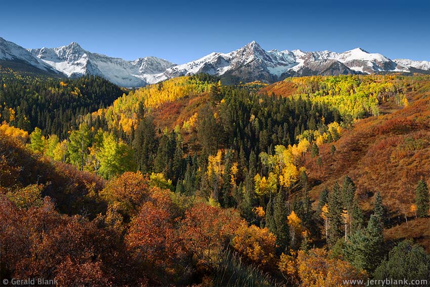
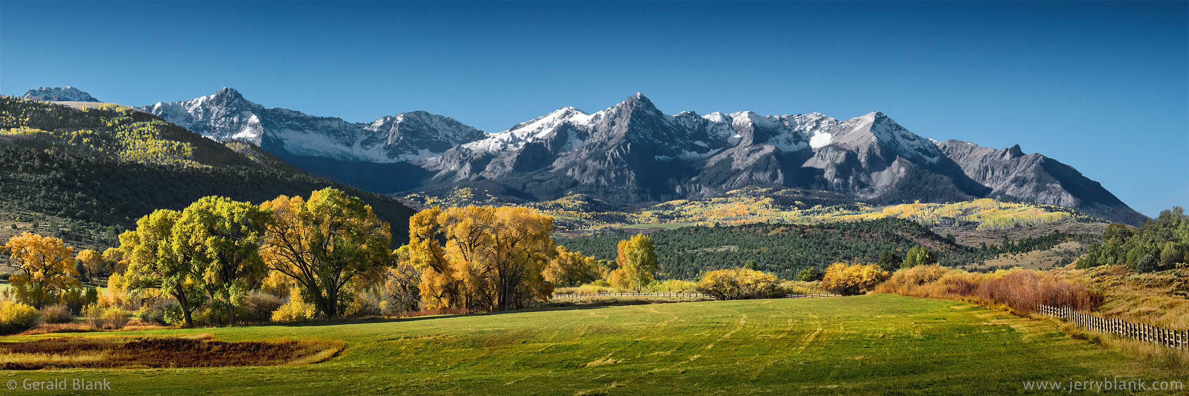
A colorful panorama, looking toward Mears Peak and
Ruffner Mountain— Click / tap image to view full size
Each autumn, the mountains of Colorado are dressed in bright warm colors, and there are many places where one can see great views just like the ones on this post. There is one mountain range within the San Juan Mountains, however, which offers not only spectacular views of fall color, but excellent access. It is called the Sneffels Range (a name which is hard for me to forget; it sounds too much like the name of a character on Sesame Street).
Early one morning in October 2008, I headed west on CO Hwy. 62 from Ridgway until I found a “West Fork Dallas Creek” sign indicating the turnoff to County Road 9 south. That location can be seen here on Google Maps.
As the map shows, the road forks in a few spots. I won’t attempt to guide you to any particular spot, firstly because there aren't that many miles of road to explore—and secondly, if you visit the place yourself in October, you’re going to enjoy the scenery along the entire route!
The view of Mears Peak and Ruffner Mountain pictured here is but one example. The foothills and the lower slopes of the Sneffels Range have a perfect mix of cedar, scrub oak, aspen, and spruce, as you can see in the picture. Though the road is short, I spent hours exploring every mile of it, and have dozens of beautiful images to show for it. There is not room to display them all on this post, which is one reason why I recommend exploring the place yourself.
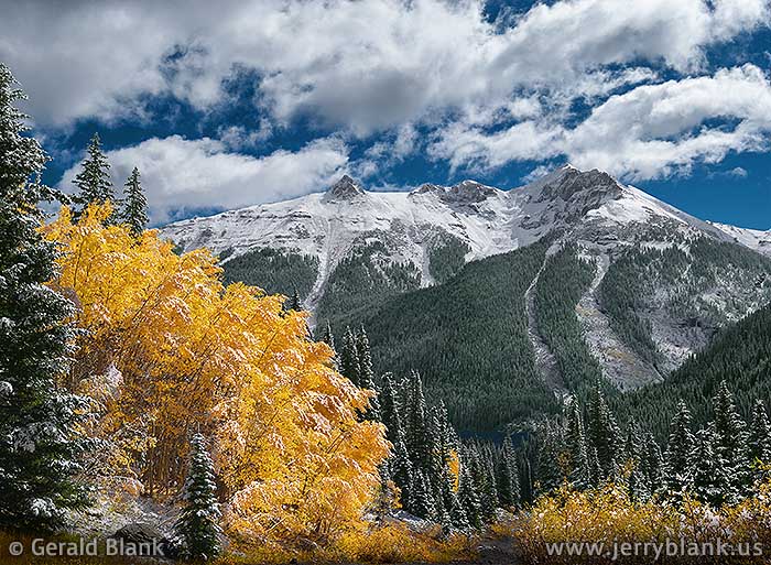
Golden aspens frame Mount Sneffels — Click / tap image to view full size
The San Juan Mountains cover a lot of territory, and one could easily take a month’s vacation to explore it all, from the high elevations late in September down to Durango in October. If you only have time to explore the Sneffels Range, though, I recommend doing it early to mid-October. However, seasons vary every year, and it’s always good to check out the San Juan Mountains Fall Foliage Report online—as well as the weather forecast—before heading to Colorado.
After spending the morning exploring Ouray County Road 9, I returned to CO 62 and found the turnoff for County Road 7 south, which you can view here.
Traveling County Road 7, I found the same abundance of great views at every turn of the road. County Road 7 is a bit longer than the other Sneffels Range access roads, because it crosses south into the Uncompahgre National Forest and ends at the Blue Lakes trailhead and a camping area at the foot of Mount Sneffels and Dallas Peak.
I captured this image of Mount Sneffels framed by colorful aspens about two-thirds of the way to the trailhead. After crossing the National Forest boundary, the road is not maintained by county road graders, so it’s quite a bit rougher. If you’re driving an SUV with AWD, as I was, you’ll do fine—provided you take it slow. There’s little point in hurrying the journey, in any case. Once you are there, it’s hard to leave...all the more so if—like me—you don’t know when the next opportunity will come!
For me, the next opportunity to return to the Sneffels Range in autumn was seven years in coming, but it was worth the wait. I arrived at County Road 9 shortly after sunrise in October 2015, and saw the panoramic image displayed below right in front of me—a very short distance from CO 62, I must add.
An early morning view of the Sneffels Range — Click / tap image to view full size
↑ RETURN TO MAIN MENU AT TOP OF PAGE ↑
In the post above, I shared the story about my first visit to the Sneffels Range, which is located roughly inside a triangle formed by the towns of Ridgway, Ouray, and Telluride in Colorado’s San Juan Mountains.
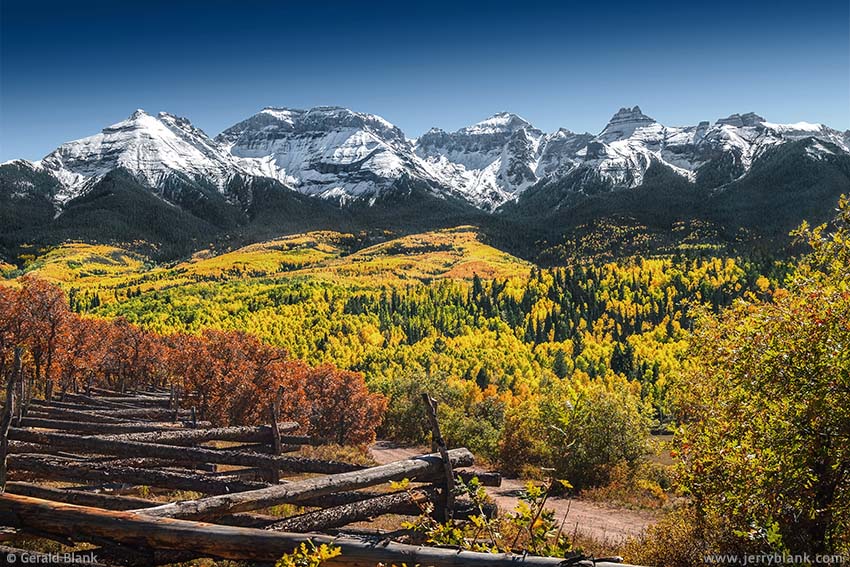
Incredible views of Whitehouse Mountain and Mount Ridgway on
County Road 5— Click / tap image to view full size
The range runs roughly east to west, and aspens are plentiful on both the northern and southern slopes. On the southern side, one’s line of sight is restricted by the narrowness of the Canyon Creek and San Miguel canyons.
It is the north side, therefore, that is considered the most photogenic, and those who travel Colorado Hwy. 62 between Ridgway and Dallas Divide in the fall are treated to a clear view of miles and miles of colorful aspen groves framed by the jagged peaks of the Sneffels Range.
All this and more could be said of other Colorado mountain ranges. What is unusual about the Sneffels Range is that it has no fewer than three county roads which allow “up close and personal” access to the mountains. I have explored all three routes, and each offers unique vistas at nearly every bend of the road. In this post, I will acquaint you with Ouray County Road 5.
Unlike County Roads 7 and 9, there is no sign along Highway 62 to guide travelers to County Road 5. But if you click here, you will see it is not so hard to find with Google Maps. From Highway 62 in Ridgway, one must turn onto South Amelia Street. After passing Elizabeth Street on the left (east) side, County Road 5 is the next right turn.
When saturated with snowmelt or rainwater, be advised that the road is a muddy mess and must be navigated with care, even if your vehicle has AWD or 4WD; I have found that when stuck in a muddy ditch off the road, AWD is of no help. When dry, the road is usually dusty and washboarded, but I will choose dust over mud any day.
The route is fairly short, compared to some county roads I have traveled. By the time you have driven a few miles, you will have climbed out of the Uncompahgre River valley and will have a clear view of the mountains. There are really no better directions I can give you than to explore and enjoy the route to your heart’s content.
Highland Drive is a side road that forks off to the north, and leads to a county park called “Top of the Pines”. The park is located at a fairly high elevation, and affords clear southwest views to Mount Sneffels, Dallas Peak, and Wolcott Mountain. Its location along Highland Drive can be seen here on Google Maps.
↑ RETURN TO MAIN MENU AT TOP OF PAGE ↑
I paid my first visit to Telluride, Colorado early in October 2008, and decided to explore Bear Creek Canyon first. The Wasatch trailhead is easy to find; it is an old Forest Service road on the south side of town, converted into a recreational trail. The trail is an easy hike, up to the waterfalls at least.
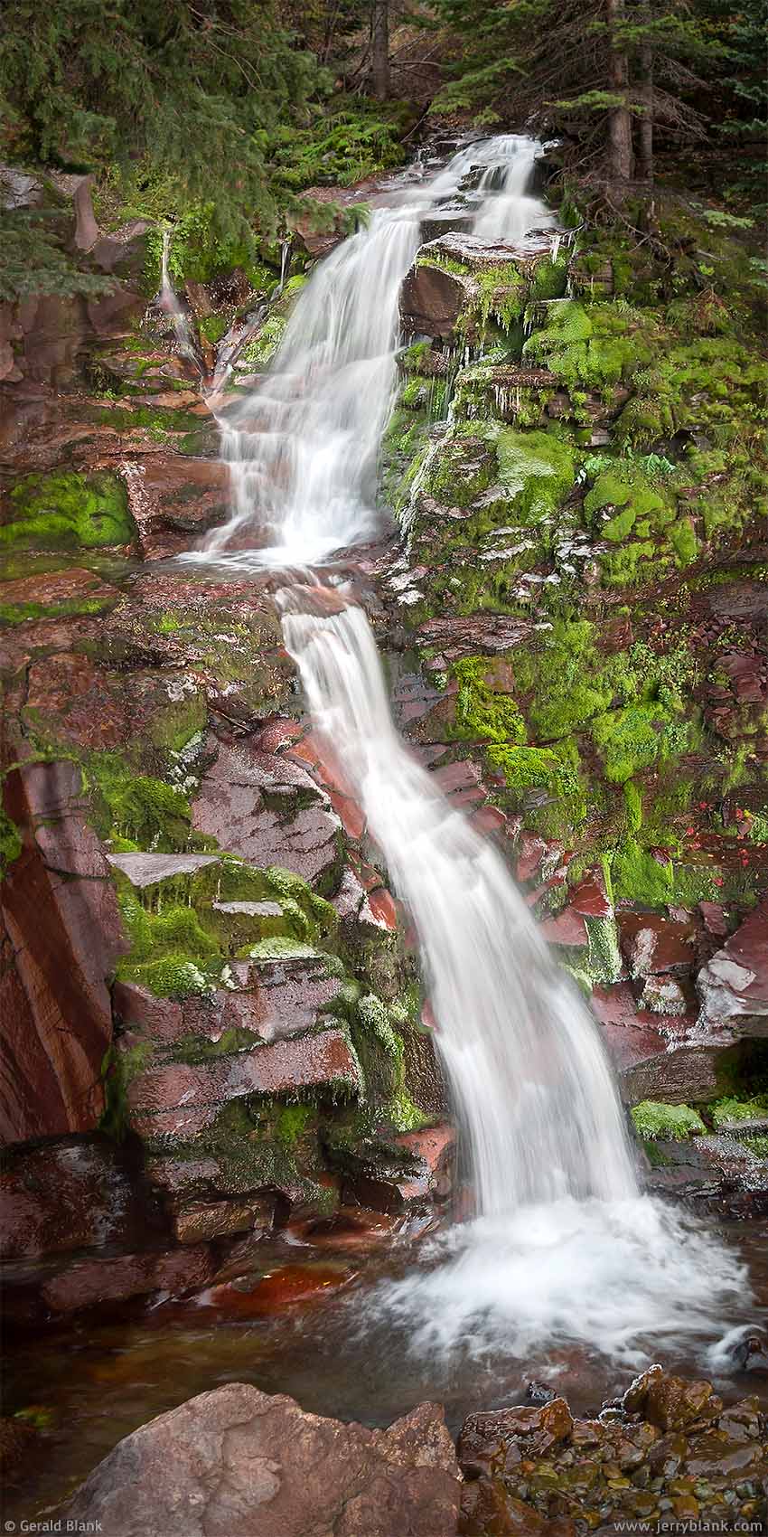
Lower Bear Creek Falls — Click / tap to view full size
After an hour, I arrived at the high part of the canyon, where Bear Creek splashes down a steep upper waterfall, then over a lower set of falls a short way back down the trail. I took a liking to the smaller lower fall because of its surroundings. The rocks over which it flows are a reddish brown color, and in spots they are covered in with green moss and little fernlike plants, which make for a nice color contrast.
Note in the photo at right that the rocks look shiny. That’s because they they were all coated with ice. I had to concentrate and choose each step carefully to avoid a spill, and the icy rocks were making my pants cold and wet. But now that I was doing the fun part—capturing the image—I didn’t mind.
As I hiked back down the canyon, the sun came out and warmed things up, and my spirits warmed up also. By the time I got back to Telluride, I was ready to find the next waterfall. (Actually, I was ready to eat. But that didn’t take long.)
Hiking above the boarded-up Pandora Mill, I found the Marshall Creek cascades. I was searching for a waterfall I had spotted earlier—and back then, there was no Marshall Creek trailhead. I’m pleased to report that one exists now; click / tap here for location info.
In 2008, I was faced with the choice of attempting to wade upstream against a strong, cold current, or to squeeze through a patch of bushes growing along the steep sides of the gorge. Unwilling to risk injuring myself twice in one day, I chose the high and dry route.
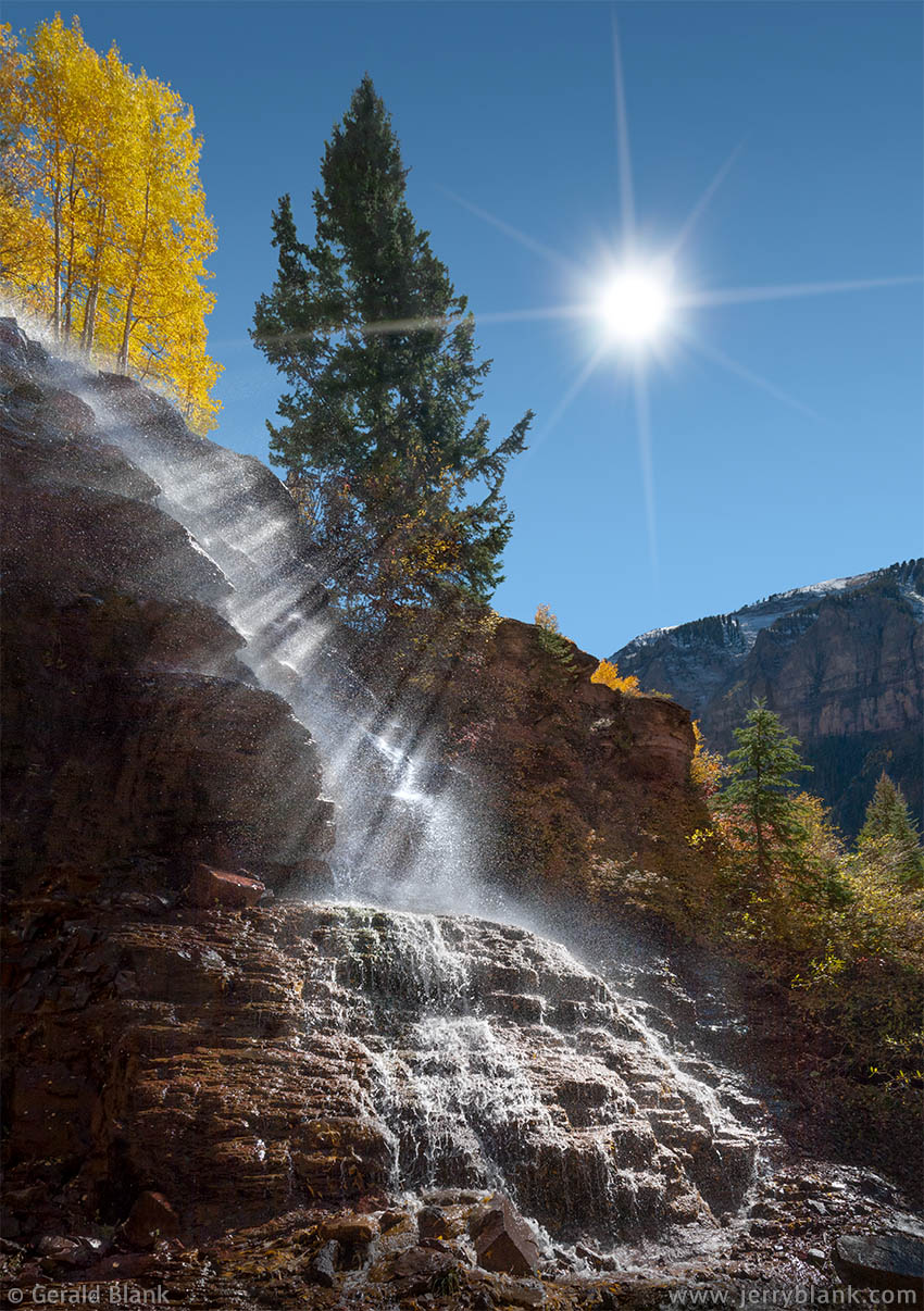
Marshall Creek Falls — Click / tap image to view full size
After I got myself untangled from the bushes, I found the waterfall, whose source was an old rusty flume pipe farther uphill. But I didn’t care where the water came from...it danced over the rocks as if alive, and the rays of the midday sun pierced through the branches of a nearby tree, lighting up the spray from the falls.
The image displayed here captures a once-in-a-lifetime moment. After upgrading to a camera which recorded good video footage, however, I hoped to outdo myself; I now know where to go and what time of day to show up. So, roughly six years later in 2014, I once again found myself squeezing through the bushes in the Marshall Creek gorge. It seemed to take longer this time. Either more bushes had grown in that spot, or there was more of me to squeeze through than on my first visit.
Soon, I emerged at the same place I had found years before—puffing, panting, and brushing leaves out of my hair. But the waterfall was gone! Only months earlier, the old flume had been replaced with a new steel pipe that ran all the way down to Marshall Creek. The delicate, terraced red rock that the water once flowed over was gouged and torn to make way for the new pipe, which is pictured here.
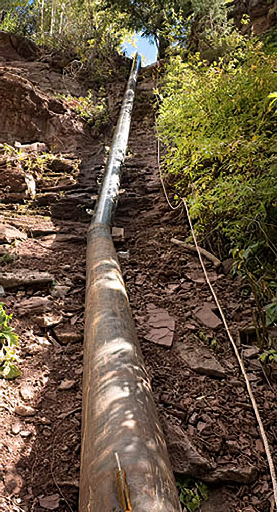
This was once Marshall Creek Falls...
I stooped down to the creek and splashed cold mountain water over my perspiring head and scratched arms. With a clearer head, I looked around and took in the scene. The plumbing work had only been done recently, I reasoned; the welds were fresh, and there was little rust on the bare steel. I had arrived but a few months too late!
When the plans of others throw a monkey wrench into our plans, frustration happens. It certainly happened to me, but that feeling dissolved in a few minutes. Perhaps because I’d taken a “time out”, I more readily accepted the truth: The image I’d captured in 2008 was already perfect, and it won’t be duplicated by myself or anyone else. The waterfall is gone, but the image above still exists for the enjoyment of all who see it.
I decided to make the best of it and capture some video clips of the creek itself, which flows through smooth, curved channels in the beautiful red rock of the canyon. After that, my attention returned to the new steel pipe. I finally noticed a rope alongside the pipe, which was tied to a tree overlooking the gorge. The rope had obviously been used by welders to get down to the creek bed, and I recognized it as my easy way out. No more bushwhacking for me! I climbed out of the gorge in minutes, and followed the pipe to a nearby construction site.
I walked up to the nearest concrete worker—acting as best I could like a guy who belonged on that jobsite—and asked him what they were building. He replied that it was to be a small hydroelectric power plant. The flume had been extended down to creek level so that the water’s gravity would create more suction on the outlet side of the turbine.
Next I pointed to the access road, and asked how far downhill it went. “Only about a quarter mile,” was the reply. Breathing a sigh of relief, I thanked the worker and left. Before long I arrived at my parking spot, which was not far from where the current Marshall Creek trailhead is located. The access road to the power plant, of course, is now secured and gated. The plant went online years ago, and provides supplemental power for Telluride.
Though I have no video footage of the Marshall Creek cascade, Telluride is blessed with other waterfalls, and I can share those pictures and video clips with you. That’s another adventure entirely, which you can read about here.