

During my travels, I’ve been fortunate to see and experience much that is worth sharing.
My hope is that these images touch your hearts, much as the USA’s natural beauty has touched mine.
May the adventurous among you benefit from the travel information I share on these pages!
The Hanging Gardens of Babylon, although considered one of the “Seven Wonders of the Ancient World”, is the ancient wonder we know the least about. Tradition holds that it was built by Nebuchadnezzar II for his queen, but the earliest surviving written account of that event is dated centuries after the Gardens were supposedly built. Unless a future archaeological discovery reinforces that account, the Gardens’ very existence will remain a mystery.
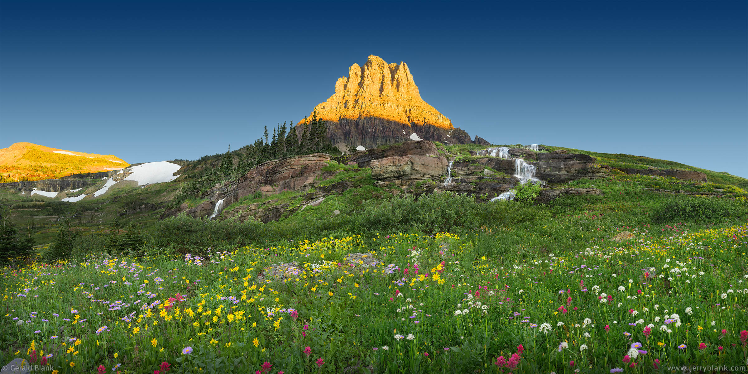
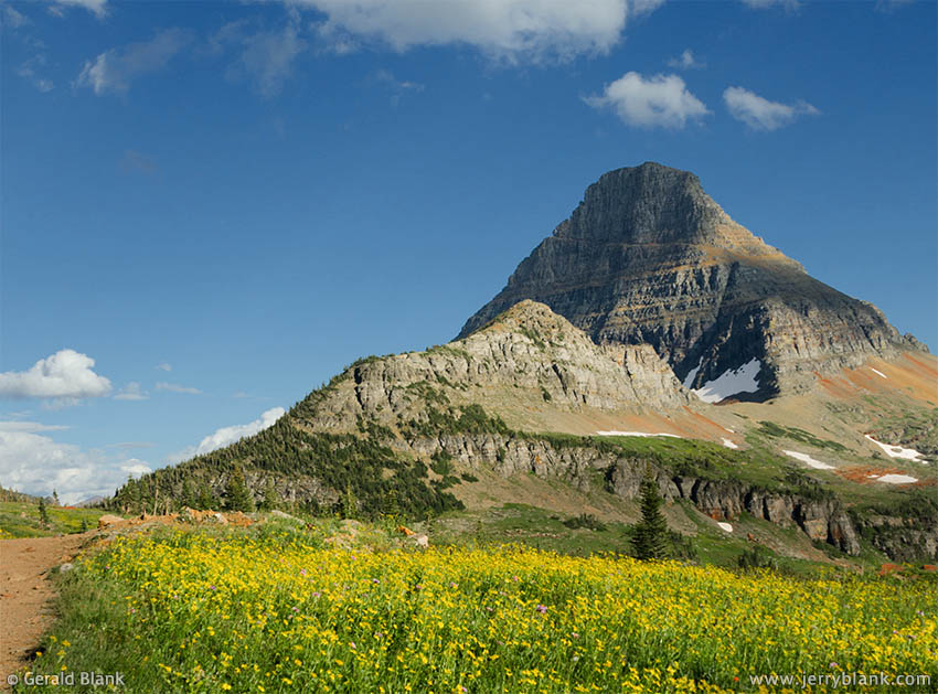
Sunrise at Clements Mountain, above the waterfalls and wildflowers in the Hanging Gardens — Click / tap image to view full size
Glacier National Park has many square miles of summer wildflowers. Possibly the most outstanding wildflower scenery is in the Hanging Gardens. Their existence was unknown to me for many years, until I became more knowledgeable about the geography of the park. Their location isn’t divulged in any park literature, and Triple Falls is not on any of the Park Service’s trail maps.
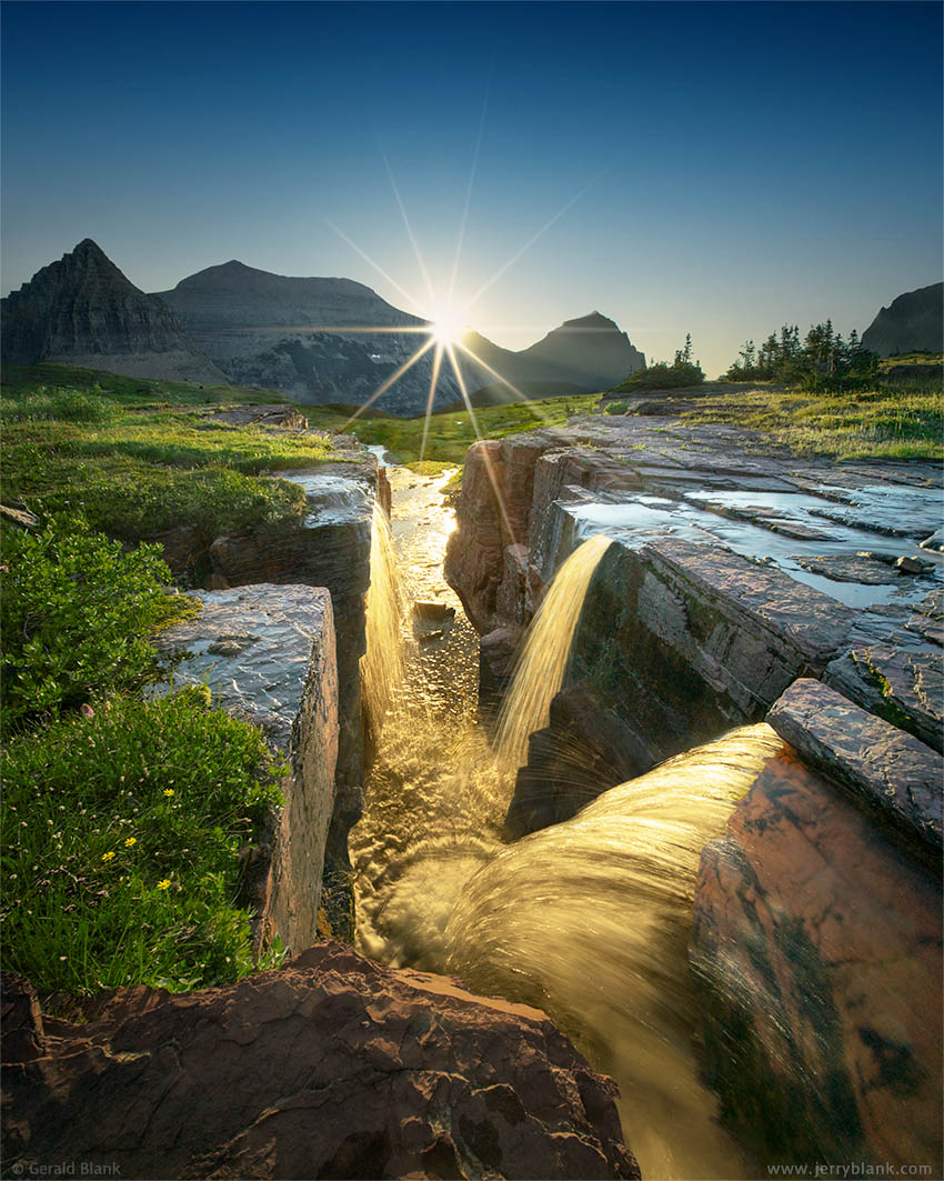
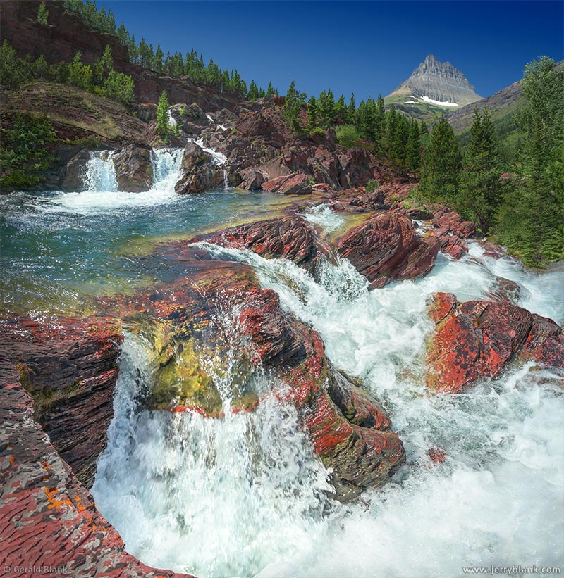
The rays of the rising sun light up Triple Falls, on Reynolds Creek in the Hanging Gardens of Glacier National Park — Click / tap image to view full size
In 2005, I was browsing a bookstore in Montana, and happened upon a newly-published book titled Montana Wildflowers, authored by a talented photographer named D. Linnell Blank. She’s not one of my direct relatives; all we have in common is our love of Montana scenery. The book contains beautiful images of Glacier’s high-altitude subalpine wildflowers, such as the ones that carpet the Hanging Gardens as soon as the snowpack recedes in midsummer.
When viewing this map on a phone, tap the “fullscreen” icon to use as a navigation guide in the park.
To switch to “satellite” view on a mobile device, tap the “Layers” icon .
If the “Layers” icon isn’t visible, you may need to tap your “back” icon.
iPhone users: If navigation doesn’t work as described above, you may need to install the Google Maps mobile app.
The Gardens are clearly visible in the upper right quadrant of an earlier photo, one that I’d captured from Piegan Mountain while climbing its slopes with my son in 2006. It ought to have occurred to me that I’d find the Hanging Gardens in a hanging valley—but it’s a small, shallow valley, and the meadows were blanketed with snow.
In the late 20th century, Galen Rowell was a well-known mountaineer and landscape photographer. I was inspired by many of the images he published in the 1990s, including an image titled Double Falls at Dawn. Eventually, I learned that the actual name of the waterfall is Triple Falls, and is located in the shallow hanging valley near the headwaters of Reynolds Creek. The creek gathers summer snowmelt from dozens of rivulets and cascades, which flow down the terraced slopes of the Hanging Gardens before making a final thousand-foot drop into the upper St. Mary valley.
Although Glacier National Park’s website doesn’t even mention the Hanging Gardens or Triple Falls, those places can now be viewed clearly on Google Maps.
The location of the Hanging Gardens was possibly kept a mystery by design, because of its fragile ecosystem. The National Park Service built a wide wooden walkway over much of the 1¼-mile trail from the Logan Pass visitor center to the Continental Divide at Hidden Lake Pass. The trail gains 500 feet of elevation in that short distance, so there are many wooden stairs to climb!
The raised walkway is an admirable bit of engineering, whose purpose is to help keep the boots of summer visitors from trampling the surrounding subalpine tundra into a muddy mush. It offers hikers a scenic view across a meadow north of the Hanging Gardens toward Logan Pass, as well as a chance to spot mountain goats and marmots near Hidden Lake Pass. After the snow recedes, wildflowers abound on both sides of the pass, and are easily seen from the trail. These wildflower meadows are sometimes misidentified as the Hanging Gardens, because of the amazing summertime views.
The “real” Hanging Gardens, with its many waterfalls and vast swaths of colorful wildflowers, lies between the visitor center and Reynolds Mountain—but they aren’t visible from the visitor center, nor from the raised walkway on the Hidden Lake trail. Park planners have not seen fit to build a similar walkway from the visitor center to Triple Falls and the Hanging Gardens. That should be remedied as soon as possible, because those areas really are worth seeing—and because more of Glacier’s visitors are coming to look for them.
I studied Google Earth’s view of the Hanging Gardens before my 2017 trip, and I determined that the easiest and least intrusive way to access the Gardens is via the Hidden Lake Trail, for the first leg of the hike. The trail climbs to Hidden Lake Pass.
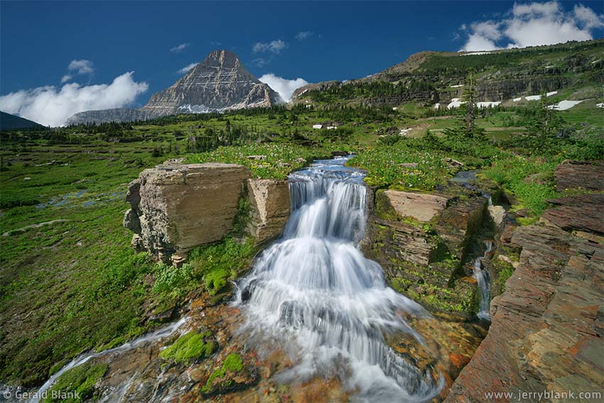
One of the many waterfalls in the Hanging Gardens, north of
Reynolds Mountain — Click / tap image to view full size
Just over 100 feet east of Hidden Lake Pass, a side trail leads south to Reynolds Mountain (a trail which is a sweet trek for agile climbers who can navigate over loose rock). That route, though well-established, isn’t visible on Google Maps unless you view Maps at this link. If one hikes south on the side trail, part of the Hanging Gardens can be seen to the east by the time one has walked a quarter of a mile. Cascading snowmelt can be heard tumbling down a rock formation along the east side of the trail.
A third of a mile down that trail, the view eastward is blocked by a forested, rocky slope. That’s the “destination point” at which one can venture east off the trail to Reynolds Mountain, because the rocky slope provides natural “switchbacks” one can use to descend safely to the Gardens below. I say “safely”, not “quickly”, because this slope doesn’t let you have it both ways unless you happen to be a mountain goat.
In fact, one must choose one’s steps with care everywhere in the Hanging Gardens. As much as possible, one should “leave no trace”, and tread on rock or gravel—not snowbanks, tundra, or vegetation. This takes a bit of skill. Inexperienced hikers should, frankly, not venture off-trail in subalpine terrain like this.
Any time one ventures off-trail in the Rockies, one might as well be in the “backcountry”, where it’s safer to hike with a companion than to go it alone. That’s another reason to build a wooden walkway from the Logan Pass visitor center through the Gardens to the Reynolds trail. It would be a great public service. It’s a shame to keep such natural beauty hidden by park policy or lack of funding.
In July of 2017, there was still some snowpack on the higher terrain near the Continental Divide. Since the snow had receded from the lower Hanging Gardens valley, the place was thick with brightly-colored wildflowers. On a clear and warm summer day, my son and I left our lodgings in St. Mary long before the pre-dawn light, so we could be assured of finding a parking space at Logan Pass—but mainly, to allow us time to hike to Triple Falls before sunrise.
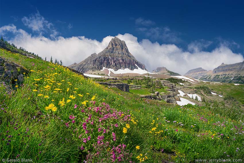
A view of Clements Mountain from the upper terraces of the
Hanging Gardens — Click / tap image to view full size
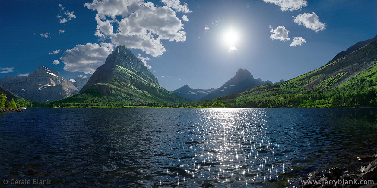
We made our way to the falls with time to spare. So, before setting up my camera and tripod at Triple Falls, my son and I took in the surrounding view of the shallow valley and its surrounding peaks. We watched the sun rising in the Great Plains east of the Rockies. Soon, its warm rays were touching the peaks of Reynolds Mountain and Clements Mountain. Facing west, I captured a panoramic image of the waterfalls and wildflowers below Clements Mountain (which can be seen at the top of this page), just before the band of bright orange sunlight reached the base of the mountain.
With that done, I quickly turned to the east, brought my tripod to the top of Triple Falls, and set it up on the same piece of reddish shale Galen Rowell had used over twenty years before (See Triple Falls photo above). Rowell’s image had been captured before sunrise. I was intent on capturing my shot at sunrise, which requires a bit of advance planning: The small slot-shaped gorge into which Reynolds Creek flows only lines up with the rising sun for a few days in July.
Shooting directly toward the sun, as many of you know, can mess up an image seven ways to Sunday. But I kept at it, trying different shutter speeds as the sunlight broke over the eastern mountains, for I was determined to capture the golden highlights in the moving water, which one only sees during the first minute of sunrise!
As one would expect, we spent a good part of the day strolling through the Gardens, where we saw many small waterfalls and colorful wildflowers. My son, despite not being “into nature” as much as his dad, appreciated the Hanging Gardens of Glacier and better understood my motives for finding and visiting them. During the short wildflower season at the Continental Divide, the Gardens qualify as one of the “Seven Wonders of the Natural World”.
↑ RETURN TO MAIN MENU AT TOP OF PAGE ↑
As with the adjoining Hanging Gardens of Glacier National Park (See preceding blog entry), I hadn’t found any information about accessing the Continental Divide ridge facing Hidden Lake before I visited Glacier with my son in July 2017.
A splendid view toward the west side of the Continental Divide ridge and Reynolds Mountain
My son arrived a day later than I did, so I used my solo time to ascend Hidden Lake Pass and find a way up to the narrow ridge.
This image has a good view of the Continental Divide ridge on the left (north) side of Reynolds Mountain. If I was built more like the mountain goats grazing near Hidden Lake Pass (and closer to their age), it would be easy to simply walk up to the summit of either ridge, and see some sweet views of Hidden Lake, Bearhat Mountain, and other well-known landmarks near the Continental Divide.
Although mountain goats don’t have to ascend mountain slopes on “game trails” the way deer and elk often do, there happen to be a few such routes under the tree cover on the north end of the Continental Divide ridge. The trees I refer to can be seen in the photo, on the left side of the ridge.
To simplify the lay of the land for would-be hikers, I’ve created the map below:
When viewing this map on a phone, tap the “fullscreen” icon to use as a navigation guide in the park.
To switch to “satellite” view on a mobile device, tap the “Layers” icon .
If the “Layers” icon isn’t visible, you may need to tap your “back” icon.
iPhone users: If navigation doesn’t work as described above, you may need to install the Google Maps mobile app.
As shown on the map, hikers on the Hidden Lake Trail cross the Continental Divide at Hidden Lake Pass, at an elevation of about 7150 feet—some 500 feet above nearby Logan Pass.
Just over 100 feet east of Hidden Lake Pass, the trail tees south toward Reynolds Mountain. During my most recent visit, this trail was unmarked, but it’s well-trodden and easy to find. A short, 600-foot walk southward on this trail will bring you to the wooded north slope of the Continental Divide ridge, on the west side of the trail.
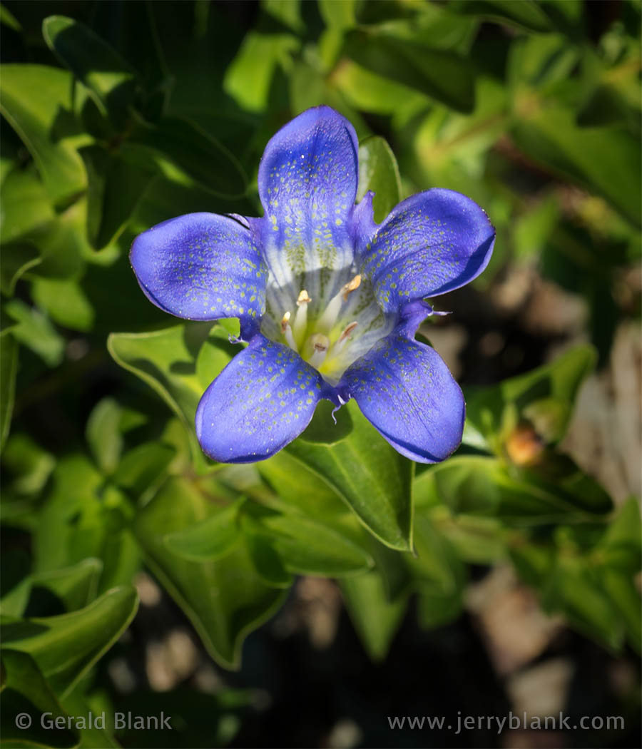
A closeup view of blue gentians
on the east side of the ridge
If you’re visiting Glacier in July, there’s a 50/50 chance that the snowdrifts in the wooded slope have mostly melted away. But if they haven’t, I can’t recommend hiking up the slope. Stick to the trails you can see.
When the snow melts away from the sunny portions of this slope, there’s a good chance you’ll see clumps of beautiful blue gentians—like the one pictured here—growing nearby. However, the meadows along the Hidden Lake Trail west of the Divide are where most of the wildflowers will be found.
As experienced trekkers will observe, hiking up the north end of the Continental Divide ridge is not very difficult. One must simply use common sense. It’s easiest to ascend in a switchback pattern, following the terrain that offers the least dense tree cover. There are game trails on the slope, but they won’t always lead upward to the destination, which is the top of the ridge.
At an elevation of roughly 7400 feet (about 250 feet above Hidden Lake Pass), the tree cover begins to thin out. The next couple of hundred feet involves climbing over small chunks of mountain rock, like so many stone stairs.
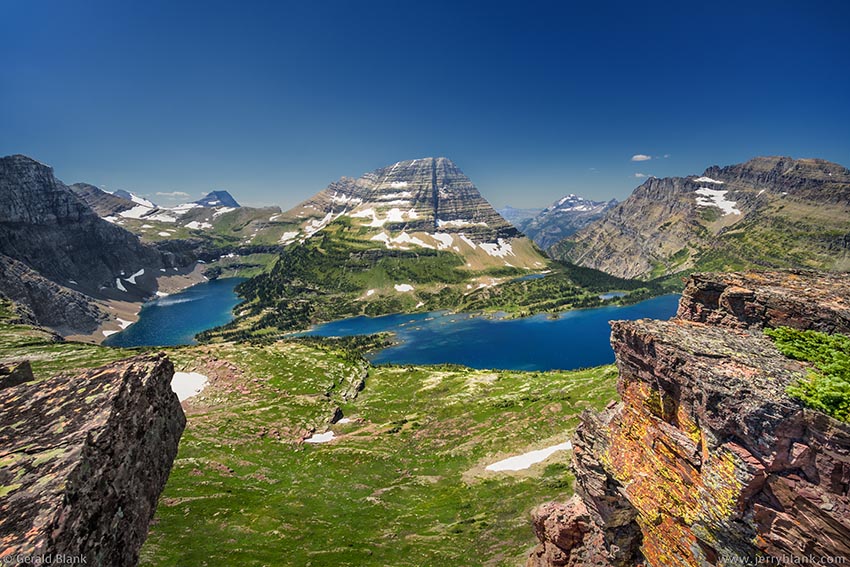
An excellent view westward to Bearhat Mountain and Hidden Lake, from the Continental Divide ridge 1200 feet above Hidden Lake— Click / tap image to view full size
By the time one can stand up and enjoy an unobstructed view to the east and the west, the elevation is 7450 feet, just above the treeline. The majority of the evergreens farther up are shrubby junipers, which tend to hug the rock they’re growing on.
That, at least, was my experience when I emerged from the tree cover on the north end of the Continental Divide ridge. Finding my way up through the trees was a short hike, but a steep one. Traversing the ridge from north to south to the summit is a more gradual elevation gain of 200 feet, and that distance is an easy climb. The ridge is fairly wide at the top, and the surface is mostly flat bare rock.
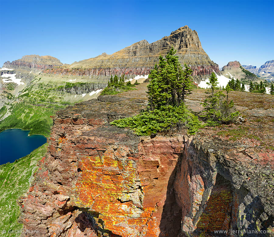
A view northward to Mt. Cannon, Clements Mtn., Mt. Oberlin, and Hidden Lake. Brightly-colored lichens cover the south-facing rock formations.
The rock surface, dry as it is after the summer snowmelt, has little grass and few wildflowers. Nevertheless, the route is quite colorful, as illustrated in the photo below. Brightly colored lichens seem to be everywhere, especially on the vertical rock surfaces facing the sun.
My original travel plans were to meet my son the previous evening, and spend this particular day exploring the Hanging Gardens and this ridge together. After learning that his arrival would be delayed by a day, I went with the flow, so to speak, and visited those places by myself. That gave me an opportunity to chart the routes I described above, to minimize guesswork when I returned with my son a few days later.
That effort paid off well the morning of my second visit, when I had my son with me. After we ascended past 7450 feet of elevation, my son began to appreciate the scale of the Montana Rockies in a way I hadn’t observed before.
Some days later, my sister’s youngest daughter and my brother Mike met us in St. Mary, and we spent time hiking along the Garden Wall on the west side of the Contintental Divide.
The day after I returned home to Florida, my son showed the others the places we’d visited on this day. After that, my brother took the lead. By the early afternoon, they reached the Continental Divide ridge from the east from the Reynolds trail, where they enjoyed viewing mountain goats. The nice thing about mountain goats who live in national parks is that they love posing for photos!
↑ RETURN TO MAIN MENU AT TOP OF PAGE ↑
Swiftcurrent Lake and Grinnell Point — Click / tap image to view full size
My family had visited Swiftcurrent Lake, a popular location in Glacier National Park, every few years since 1991, the year before my son’s birth. The evening scene pictured below is what one typically sees from the west decks and balconies of Swiftcurrent Lodge, or from the bridge under which the lake’s outlet surges east to a waterfall on the east side of the bridge, as it flows eastward to the Lake Sherburne reservoir.
What I was hoping to find was a warmer-colored setting sun and sparkles on the lake surface. But that kind of coloring comes with higher concentrations of dust or wildfire smoke in the air, so I was content to work with the crisp mountain air I was breathing on that evening at the end of July.
The other thing I would have preferred is calmer air; that would have minimized rippling in the lake, creating a nice reflection of Grinnell Point. Again, I had to accept a trade-off: Lots of sunlight sparkles in the lake, but only a faint reflection of Grinnell Point on the lake surface. The closer one gets to the Continental Divide, the more one must contend with mountain breezes.
↑ RETURN TO MAIN MENU AT TOP OF PAGE ↑
As I wrote in the preceding blog entry above, my family and I had explored Swiftcurrent Lake, as well as the trails closer to the Continental Divide, such as the ones above Lake Josephine and Grinnell Lake.
Redrock Falls and Mount Wilbur — Click / tap image to view full size
Like many family vacationers, though, we were intent on covering the most popular scenic places in a week’s time. Only after my son reached adulthood did the two of us begin to explore the “trails less traveled”. So it was not until this trip, in 2017, that I made up my mind to explore the upper section of Swiftcurrent Creek from a well-worn trailhead at the Swiftcurrent Motor Inn and gift shop.
Late in the morning, we got off the trail where it skirts Redrock Falls, to enjoy some shade and capture some photos. For capturing this waterfall, I chose a 10mm ultra-wide-angle lens. I liked the way it “magnified” the lower falls, only a dozen feet in front of my tripod.
I wasn’t liking the bright sunlight as much, though. If ever we visit this waterfall again, I will definitely make a point of capturing a slow-shutter-speed image just after sunset.
For this image, I made the best of what I had by placing a neutral density filter over the front of the lens, and I captured the scene using a range of shutter speeds.
After returning from our trip and viewing the images on my large monitor, I was surprised to see “motion blur” in the water closest to my camera, in images shot at 1/250 second!
As it turns out, not only does an ultra-wide lens exaggerate the size of the center of the image, it exaggerates the apparent motion of whatever happens to be in the middle of the frame. In this image of Redrock Falls, there’s no motion blur in the water outside the center of the frame—exactly the result one expects at 1/250 second. At first, I wasn’t sure I liked the sharp variation. But the longer I looked at the 1/250 second image, the more it grew on me. I chose this shot over similar ones taken at slower speeds.
Although the 10mm ultra-wide lens served me well for this shot, I learned after returning home that the edges of ultra-wide images are usually stretched out of proportion. As a result, I was spending a lot of time in Photoshop correcting that distortion. Before my next photo safari in the mountains, I switched to more modest 18mm wide-angle lens.