

During my travels, I’ve been fortunate to see and experience much that is worth sharing.
My hope is that these images touch your hearts, much as the USA’s natural beauty has touched mine.
May the adventurous among you benefit from the travel information I share on these pages!
In a previous blog entry, I explained how—after slumbering for over a dozen years—my itch to get outside to capture wildlife and scenery pictures re-awakened, about the same time as digital cameras were getting affordable. My first digital camera was an 8 megapixel point-and-shoot type, not much better than a modern phone camera, except that it had a decent power zoom lens. But it served me well for a year, as long as there was enough light to avoid sensor noise.
Springtime arrives late in North Dakota. In town, lawns start greening up and tulips begin blooming early in May, but the countryside is normally brown till late in the month. I was nearly stir crazy after the long winter, and hit the back roads as soon as there was color to be found, somewhere out there... It was there, if only in small patches at first.
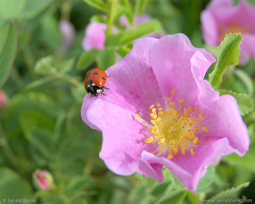
Ladybug on wild rose in North Dakota — Click / tap image to view full size
The wild rose, which is the state flower of North Dakota, brings color to moist patches of prairie by June. In the northern Plains, there are wild perennial flowers for every season (except for the eight-month winter). In my previous blog post, I shared some samples of early autumn wildflowers. The flowers pictured in this posting, on the other hand, show what one can expect to find during a Northern Plains spring.
Those of you with point-and-shoot cameras shouldn’t think your equipment will prevent you from geting great images. On the day I captured the ladybug image at left, my camera’s small sensor worked to my advantage, with its generous depth of field. I never had it so lucky with my old full-frame film camera, with its much shallower depth of field.
Every time I see some amazingly beautiful images on Flickr, Facebook, or Instagram, I am reminded that great photos often don’t require great equipment.
I did upgrade to a DX-format Nikon outfit in 2007, though, and shortly afterward, I was on a photojournalism assignment west of the Little Missouri National Grassland. The entire day was overcast and rainy, which didn’t interfere with my assignment because it was indoors. But I had hoped for better weather, knowing there might be time for a “fun” shoot on the way home.
After my work was done in the afternoon, I took to the road. The rain had finally stopped, but the sky was still heavy and overcast, and I held out little hope for a change.
After traveling north some miles, I turned westward. To my surprise, I spotted a telltale sliver of light hovering over the distant horizon. I covered the remaining distance to the main highway in a half hour, my eyes glued to the sliver of light that was now spreading a bit wider, revealing a bright sky beyond distant hills.
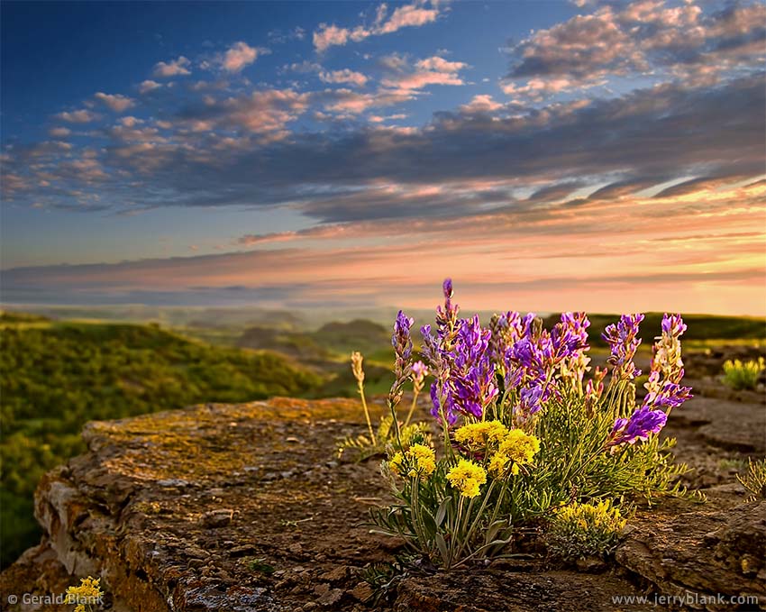
Wildflowers on weathered sandstone — Click / tap image to view full size
At the main highway, I stopped, consulted my map of the National Grasslands, and located the nearest gravel access road. Not long after I made it inside the boundary of the Grasslands, I found a pasture filled with purple milkvetch and many other springtime flowers. I had only been outside my SUV for a few minutes when the sun broke through the clouds at last, as if to prove it would not let this day go by without putting in an appearance. The pasture, which had looked fine under cloud cover, fairly came alive under the rays of the evening sun.
It was late, though, and I saw that by the time the western clouds lifted fully, the sun would very close to setting. I jumped back into the SUV, therefore, and sped off again, in search of a place with an expansive view to the west.
Fortunately, I found it in time: A trailhead for the Maah Daah Hey trail, a popular route for trail bikers and horseback riders. The trail head provides access to a sandstone bluff overlooking the Aspen Trail and the Ice Caves Trail, a popular pair of spur trails encircling Ice Caves. I was amazed to see healthy-looking wildflowers growing in every available crevice in the rock. Normally, lichens are the only colorful living things to be found on a North Dakota rock—but these plants, gray and dried-up for nearly a year, sprang to life when touched by the spring rains. Their time for flowering is typically very short—but it was the moment at sunset where they looked truly luminous. I’m glad I was there to capture that moment, and to share it with you. I shot other photos after sundown, but this is the one that was the “keeper”.
By the time I made it back to the paved highway and resumed the trip home, the sky was clear and dotted with stars, except for the pleasant post-sunset glow in the west. Though I had seen very little of the sun that day, I was very grateful for the little bit I had while laying down on a chunk of sandstone, admiring spring wildflowers through my viewfinder.
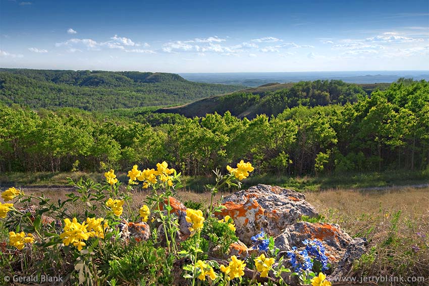
Springtime in the Killdeer Mountains
The following spring, I was exploring the Killdeer Mountains, which lie just east of the National Grasslands in Dunn County. Though merely a series of erionite bluffs no more than 700 feet high, they’re the closest thing to mountains one will find in western North Dakota. With the extra moisture these hills get, they’re able to sustain a thick scrubby forest of aspen and bur oak, which is rich in wildlife.
Most wildflowers favor open sun, however, so they’re found wherever the forest gives way to grass or rocks. Erionite is a chalky, soft white rock, and if it’s been laying out in the sun, it is usually covered with bright red-orange lichens. Like the sandstone outcrops in the National Grasslands, these rocks play host to numerous wildflowers, as long as there is moisture to sustain them.
After driving a ways on a little-used access road through the forested hills, I came across an open pasture dotted with chunks of erionite, nestled in carpets of juniper. Wherever there was a gap in the juniper, yellow goldenpeas, blue beardtongue, and spring grasses could be seen. Down at the level of the rocks and boulders, the wildflowers looked amazing next to the brightly-colored lichens.
It was late in the day when I captured the photo above, though not as late as the photo I had taken on the sandstone outcrop. The older photo seems to have more warmth and character to me. But I like this picture also. It displays the character of the Killdeer Mountains well, for the benefit of those who haven’t been fortunate enough to explore them as thoroughly as I did. It’s my hope that you will have your own chance to do that someday, wherever your back roads happen to be!
↑ RETURN TO MAIN MENU AT TOP OF PAGE ↑

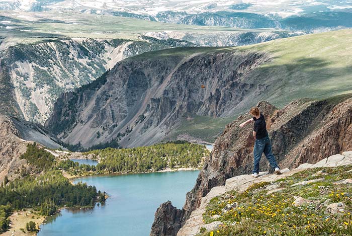
Scenic view from the Rock Creek Overlook on Highway 212 south
toward Beartooth Pass — Click / tap image to view full size
US Highway 212 from Red Lodge, Montana to the northeast entrance to Yellowstone National Park is a scenic byway called the Beartooth Scenic Highway. Though I enjoyed my first visit to Red Lodge and the Rock Creek valley at the end of 1991, I was unable to explore Beartooth Pass because it’s only open for traffic during the summer months. During that first visit, I got my first ski lesson at Red Lodge Mountain, which had a healthy covering of snow—but Beartooth Pass, at its elevation of nearly 11,000 feet, is literally buried in snow until the rotary plows make their annual early summer trip to clear Highway 212.
Those of my friends from North Dakota who visited Beartooth Pass had nothing but praise for the scenery, so by the turn of the century I decided to make the first of my two visits to northern Wyoming via Highway 212. On both visits, my son and I stopped at Rock Creek Vista to get our first good view of Beartooth Pass, which lies just above and beyond the deep Rock Creek valley pictured here. It should be obvious that the snapshot of the two of us is a vintage photo; we may not have changed much inside, but on the outside we both look much older now!
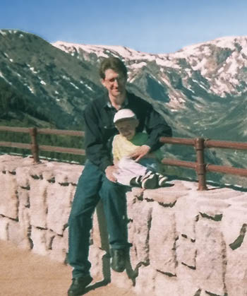
Our first trip to Beartooth Pass,
near the turn of the century
Our next trip was made some years later, in 2007. By that time I had acquired a Nikon digital camera, some more photography experience, and a couple dozen pounds. My son had likewise grown; he was on the verge of surpassing his dad in height, and of getting his driver’s license.
We overnighted at Red Lodge on June 21, 2007, and took to the road early the next morning. As we had done on our previous trip at the turn of the century, we parked awhile at Rock Creek Vista. I was not happy with the view at the parking lot, though, and wanted a higher vantage point. Back then, drone-mounted cameras were a rarity—handmade, for the most part, difficult to fly, and very expensive. Therefore, we took to the short trail leading north from the parking lot, then bushwhacked uphill a bit to the west until we found the weathered tree trunk pictured here. I was much more pleased with the view from this place, and my son indulged me enough to sit on the log so I could take a couple of pictures of him. I captured more images after he jumped off the log, one of which is displayed here.
This place obviously has sentimental value for me, but the photo is also popular with many other viewers because of its excellent view of the Rock Creek valley, which stretches behind Rock Creek Vista for miles—all the way to the Montana-Wyoming border below the summit of Beartooth Pass.
My son gauges the distance to Twin Lakes by tossing a rock down the gorge
The distance to the state line was not far, as the crow flies, but those without wings must take a series of switchbacks with hairpin curves to reach the summit. About a half hour after departing Rock Creek Vista, we found ourselves at a scenic overlook of Twin Lakes, which is pictured here.

A view of alpine wildflowers, with Hellroaring Plateau in the background
This part of Highway 212 is just south of the Montana-Wyoming border, which runs roughly in line with the far side of the most distant lake in this photo. You’ll note that trees surround the shores of Twin Lakes, but our vantage point was about 900 feet higher in elevation—already well above the treeline. We didn’t have the Google Earth smartphone app back in 2007, so my son gauged the drop from our ledge to Twin Lakes by tossing rocks into the closest lake.
Depending upon the timing of one’s visit, travelers will see wildflowers in the treeless alpine meadows sloping up gently toward the summit of Beartooth Pass. We had arrived too early in the summer to see wildflowers at the summit, though; there were still large snowbanks along the highway, the remnants of deeply-piled drifts left by snowplows a month earlier. My son and I cannot resist throwing summer snow at one another; it’ usually a perfect consistency for making really hard, icy snowballs. I enjoy the sport, even if the high altitude makes my head hurt as it did that morning.
The Beartooth Plateau, and nearby Hellroaring Plateau, though rugged, are great places to visit during the summer months. With the area’s many alpine lakes, the plateau country draws anglers, hikers, and campers from all over the country—but never so many that one feels crowded. In this remote section of the Rockies, there is space enough for everyone who cares to come. That is due in part to the fact that the 1475-square-mile Absaroka-Beartooth National Wilderness Area lies only a few miles north of the highway. Some of the finest scenery in the Rockies can be found there. In the national wilderness, mechanized travel—even by mountain bike—is prohibited. Visitors are obliged to ride hoofed critters instead—or hoof it themselves.
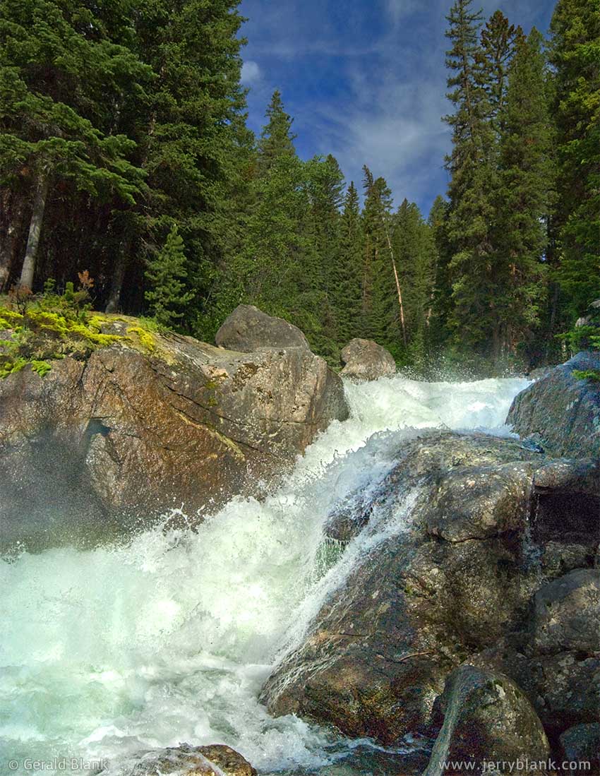
Scenic Lake Creek Falls, alongside Highway 212
Even if you’re a casual day hiker like me, you’ll enjoy splendid views of alpine lakes and snow-capped mountain ranges right from Highway 212. As one drives west and the elevation begins to drop, trees soon return to the landscape. There are several scenic landmarks to visit along the route, such as Beartooth Lake and the adjoining campground, and Beartooth Butte.
A little farther westward, there is a pullout on the side of the highway for folks who want to stop and visit Lake Creek Falls, which is pictured here during the high water season. If camping near the cascades of Lake Creek seems appealing to you, there is a campground downhill from the waterfall, on Crandall Road.
Lake Creek is one of the tributaries of the upper Yellowstone River, and by this time my son and I were not far from Cooke City, a small tourist town, and the “Silver Gate” entrance to Yellowstone National Park. My son expressed an interest in seeing Old Faithful geyser before heading to the motel I had booked in Bozeman, Montana. Although I knew that would be a longer drive than traveling north on US Highway 89, I was happy to let my son pick the route and go south on Highway 89 instead. I even let him take the wheel of our SUV; at that time, he was still learning how to drive, and I looked forward to taking a snooze in the passenger seat.

The day’s destination: Old Faithful geyser, Yellowstone National Park
Many miles later, my son was beginning to show his impatience as the afternoon wore on. Part of the problem was the lack of scenery in that corner of the park. I explained that in 1998, a few years before he was born, forest fires had burned over 30 percent of Yellowstone National Park. The forest had regenerated, as forests do. The new stands of lodgepole pines were healthier and denser... but mile after mile of densely-packed young evergreen trees is monotonous, as scenery goes.
The other issue is the fact that Yellowstone National Park is not as mountainous as many folks believe it to be. In most of the park, one literally “can’t see the forest for the trees.” If one wants a grand sweeping view of the park, one has to visit the Mount Washburn overlook, or head into the backcountry. Yellowstone Lake and the surrounding access highway are at a relatively low elevation, located in the ancient caldera of the Yellowstone supervolcano. The park is rich in wildlife and other features that justify its popularity. It just doesn’t offer the same alpine views as the ones we’d seen on Highway 212 earlier that day.
Yellowstone is more renowned for its volcanic geology, which created the Grand Prismatic Spring and Yellowstone’s other hot springs and geysers. My son, intent on reaching our destination, was not inclined to spend time at the other geologic features—not when we were so close to Old Faithful. But we were delayed anyway, by the 20-minute traffic jam on the highway north of the geyser. There is a reason such places are called tourist “traps”! Though we were way out West, the highway and parking conditions resembled those of Disney World.
Happily, we did arrive, parked our SUV near Old Faithful Lodge, and walked a short distance to find a good viewing spot behind the barrier railing. We only had to wait a few more minutes before the geyser erupted. It was a better than average performance, and I was impressed to see so many tons of water defying gravity and shooting upward. I haven’t done the math, but I do know it takes a lot of underground heat and pressure to make that happen. My son, on the other hand, was underwhelmed, and muttered: “I can’t believe we drove all this way to see that!”
“Don’t be so glum, chum,” I chuckled, pointing to Old Faithful Lodge. “A large ice cream cone should make our trip worthwhile.” It did, at least, for me.
I didn’t linger long at Old Faithful Lodge. We took to the road once more, and watched a large herd of elk graze along the Madison River just before leaving the park at West Yellowstone, Montana. Yellowstone National Park is unique in the world, and popular for that reason—yet what we enjoyed best that day, by far, was our morning journey over the Beartooth Scenic Highway.
↑ RETURN TO MAIN MENU AT TOP OF PAGE ↑
One can find acres of wildflowers in North Dakota during the brief summer season, but not unless one explores roads less traveled, to places cultivated by Nature instead of by the plow. In an earlier post, I shared some examples of early-season wildflowers that aren’t hard to find. And by early July, things really start shaping up in the grasslands and badlands.
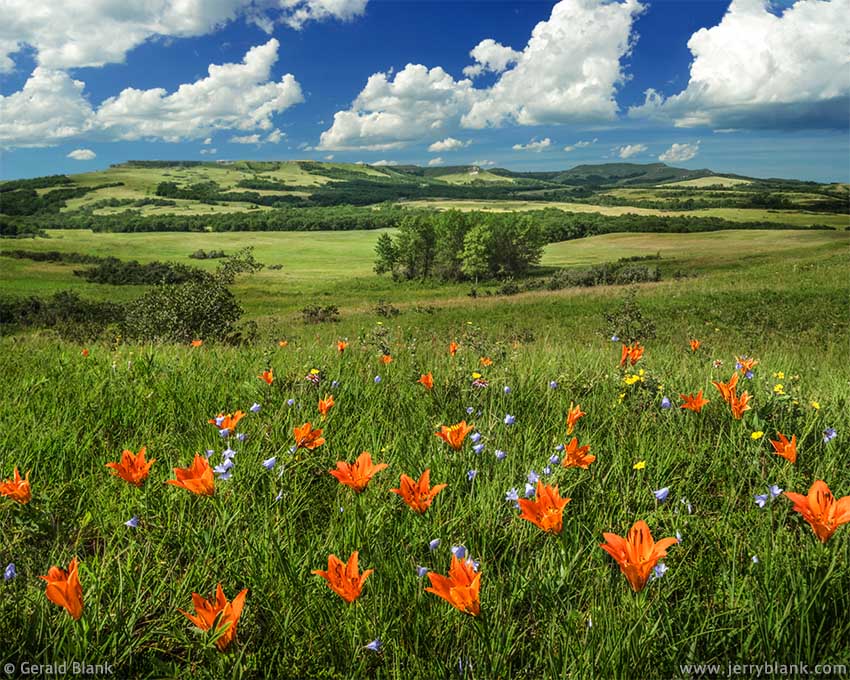
Prairie lilies in the Killdeer Mountains — Click / tap image to view full size
Dunn County may have the most extensive variety of perennial wildflowers in the state, beginning with yellow arnica in early June and wrapping things up with yellow rabbitbrush in September. Not much of the county falls within the boundaries of the National Grasslands, though, and the Killdeer Mountains is composed mostly of private land. Pictures of its unique landscape are hard to come by.
Therefore, I took some time to circumnavigate the “south mountain” (actually, a large butte), drive up to ranch houses, knock on doors, and get permission from landowners to explore the area. Names that come to mind are ones like Murphy, Veigel, Sand, and Killdeer Mountain Outfitters, and I am grateful to all of them for the access I was granted.
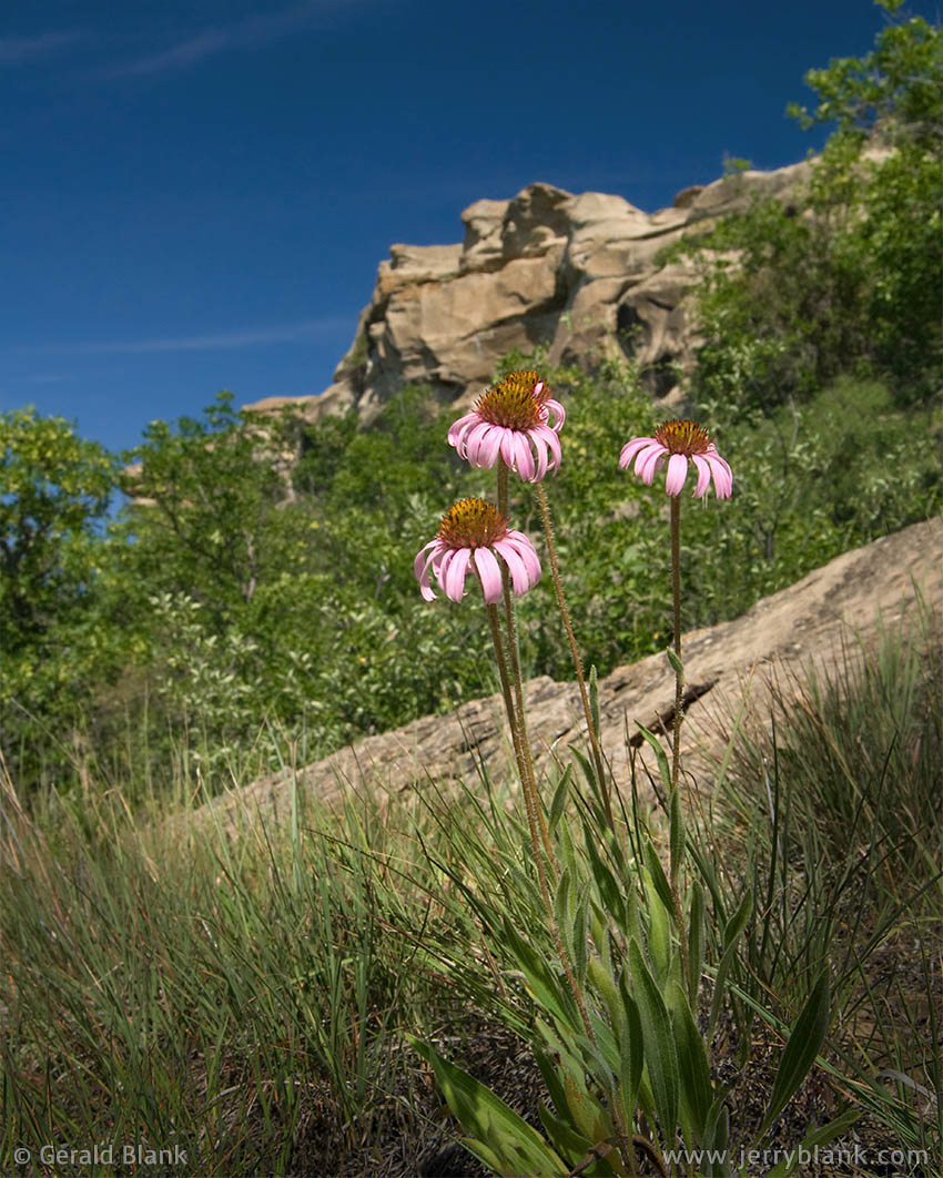
Purple coneflowers above Ice Caves
The Sands, in particular, gave me much background information about the wildflowers and wildlife in the hills. They spoke of “tiger lilies” which made their appearance every season near the beginning of July. This was news to me! I had not so much as heard of anything that showy outside of a manicured garden in North Dakota. But I checked online, and sure enough I found a listing of the “prairie lily”, which closely resembles the tiger lily, but with much shorter stems. And the info the Sands had given me was spot-on; numerous patches of prairie lilies, such as the ones pictured above, arrived on schedule in late June and early July.
In 2007, I began the Fourth of July by driving to the Ice Caves trailhead in Billings County. I had seen excellent wildflower displays in the National Grasslands in June, and I looked forward to what might be found in July.
I was not disappointed. A few miles off the highway, just after crossing the boundary into the Grasslands, it seemed that, suddenly, the shoulders of the gravel road were decorated with wildflowers of all colors.
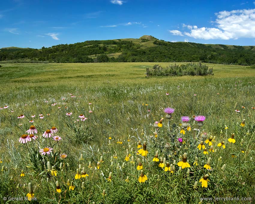
A pasture filled with coneflowers, thistle, and other wildflowers
Below the access road to the Maah Daah Hey trailhead, there are sandstone cliffs overlooking the caves and the nearby Aspen Trail. The stony bluffs had hosted some delicate early-season wildflowers in June, but those had faded away for the season. Looking down from the cliffs, however, I saw trees, sandstone boulders, and grottos—and plenty of wildflowers. In the sunny spots, purple coneflowers grew abundantly amongst the grass and rocks. The cliffs and trees behind the flowers made a great natural backdrop for the coneflowers.
As midday approached, it occurred to me that I could head west and reach the Killdeer Mountains in about an hour. My thought was to head to the Sands’ place on the south end of the hills. I wasn’t sure what I would find there, but I could always depend upon the hilly terrain to provide a natural backdrop for my photos.
I arrived at my destination just in time; the Sands were just leaving to attend the Fourth of July parade in Killdeer, but graciously invited me to let myself into their pasture. I thanked them, and said I would look for them in town that afternoon.
Once inside the gate, I was pleasantly surprised. I had never seen their pasture look so colorful; the photo at right is but a taste of the scene I viewed. I started walking through the flowers toward the knoll in the background, searching for the perfect angle, but quickly realized the flowers were just as thick in every direction, and so I walked back and captured this image from the gravel driveway.
As I have received many helpful tips from others, I am happy to share the few I have to offer. One of them is this: In the close-up shots of the orange lilies and the purple coneflowers, note that the camera angle is very low. Few Northern wildflowers grow tall, so getting one’s camera down to ground level often makes all the difference. I also use a wide-angle lens when many flowers are in the frame; that way, the background has some blur, but most of the blooms appear sharply focused. That is just my personal preference, though. You may prefer a very shallow depth of field—so if a longer lens delivers the images you like, then go for it!