

During my travels, I’ve been fortunate to see and experience much that is worth sharing.
My hope is that these images touch your hearts, much as the USA’s natural beauty has touched mine.
May the adventurous among you benefit from the travel information I share on these pages!
In the decades to come, Glacier National Park may have to be renamed. The glaciers that were discovered there over a century ago have retreated steadily ever since, due to climate change—and none of them were particularly large to begin with. They’re not expected to exist at all by the year 2050.
The Montana Rockies get quite cold in the winter, but they receive nowhere near the snowpack that’s seen on the Pacific coastal mountains. That’s why the grandest glaciers in the U.S. national park system are found in Alaska.
However, there’s one park in the Lower 48 which is no slouch, either: Mount Rainier National Park in Washington.
Mount Rainier, due to its location and its sheer size, is currently covered in about 30 square miles of glacial ice. If you want to visit a national park that has trails offering excellent views of real glaciers, I recommend visiting this page on the NPS website.
In Glacier National Park, much airborne moisture from the Pacific side of the Rocky Mountains is trapped at the Continental Divide. Although storms frequently cross eastward over the mountains and drop moisture into the tributaries of the Missouri, those who travel westward over Logan Pass can see the evidence of the wetter climate even before reaching the McDonald valley west of the pass. Upon reaching the valley, one can explore the Trail of the Cedars with its lush undergrowth of ferns.
The view at the Continental Divide — Click / tap image to view full size
The morning after my son and I crossed Logan Pass, we hiked to the Grinnell Glacier overlook. It lies only 4½ miles straight north of the meadow from which I took the picture shown here—but due to the piles of scree and talus skirting the mountains in the photo, few attempt such a route. Visitors are obliged to drive two hours farther to reach the Grinnell trailhead.
On August 3, we returned to the Logan Pass visitor center and decided to hike over the Continental Divide via the Hidden Lake Trail.
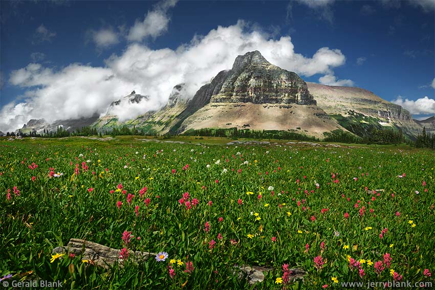
From lower elevations, where most of the park’s trailheads are located, it’s nearly impossible to know if a summer morning of blue skies is about to give way to an afternoon storm. The only warning one gets is some friendly-looking, white, puffy wisps of cloud that float benignly over the Divide, usually from the west as seen at left. As often as not, the puffy white clouds are quickly followed by an ominous wall of dark gray; any hikers in the area are greeted by thunder soon enough.
As we hiked up the Hidden Lake Trail, I paused to capture several dozen images of the scene; the alpine wildflowers seemed to stretch as far as the eye could see. It is one of those “you gotta go there” parts of the world, and my intent was to bring a piece of the Divide back down with me to share (assuming such a thing can even be done). I could write another whole blog entry on the subject of Glacier National Park’s wildflowers—but to illustrate the point I made above, you will notice the vivid, nearly fuchsia-colored hues of the rosy paintbrush in the meadow.
↑ RETURN TO MAIN MENU AT TOP OF PAGE ↑
The Hidden Lake trail is a popular route which leads westward over the Continental Divide and offers excellent scenery. My worries about finding good scenery so late in the season were unnecessary, because most of our hiking was done in the higher altitudes of the park. East of the Rockies, the Plains scorched in late-summer heat, but in our little corner of the Universe, it was springtime.
Clouds over Bearhat Mountain and Hidden Lake—
Click / tap image to view full size
We had just arrived from the Avalanche Creek drainage, a short distance west. It isn’t visible in the photo at right, but the north side of Hidden Lake (right side of photo) cascades down to the valley beyond and merges with Avalanche Creek, not far above Avalanche Falls. An unusually large amount of Pacific moisture is funneled into this corner of Glacier, and the Avalanche Creek trail is lined with giant cedars not seen elsewhere in the park; the soil is boggy and lush with ferns, so the lower part of the trail is raised to protect the fragile undergrowth.
The moist air typically can go only a few more miles eastward before colliding with the cold, high ridge of the Continental Divide. Those hiking down to Hidden Lake can see that ridge, nicknamed the “Dragon’s Tail”, off to the south. To take the imagery a step farther, Reynolds Mountain can be considered the dragon’s “head”, on the left side of the photo.
As late as August, one can still find large patches of snow on the mountains of the Divide. These patches melt at a leisurely pace all summer long, filling Hidden Lake via countless mini-cascades and rivulets. When this photo is printed large enough, one can see no less than half a dozen of these rivulets in the lower half of the picture.
My son takes a break from reading to check out the view.
My son and I took a break below one of the larger cascades, a beautiful wall of water fed by a patch of snow on the south side of Clements Mountain. Part of the lower slope of Clements, leading down to the lake, is a deep maroon-colored shale, which shows its color well during a rain.
Though the clouds looked threatening by the time we stopped, as of yet there was but a sprinkle of rain, and my son stretched out on a table of maroon shale alongside the waterfall, glancing up every so often to see if I was done taking photos yet.
He did not have to wait long, and we retraced our steps eastward back over the Divide to the Logan Pass visitor center. By the time we crossed the Divide, the clouds had dissipated and rain no longer seemed likely. But the weather of the Continental Divide, as they say, is subject to change without notice.
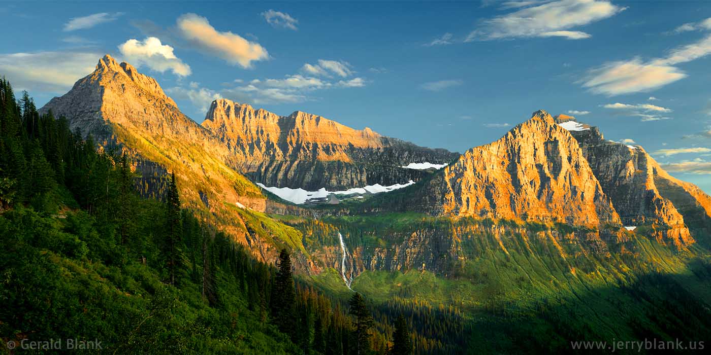
In past trips to the Montana Rockies, I was not as aware of the potential of light vs. shadow, and usually wouldn’t bother taking scenic photos if there wasn’t a clear blue sky in the picture. Being a bit wiser and a lot older now, I’ve learned to be open to all possibilities. Oftentimes it pays off, as can be seen in the image above. A blue sky can be nice, but it can also be just too ordinary. To make the scene extraordinary, sometimes all one has to do is throw in some Pacific moisture and stir gently!
↑ RETURN TO MAIN MENU AT TOP OF PAGE ↑
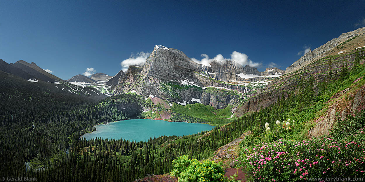
I had hiked the Grinnell Glacier trail in Glacier National Park seven years ago with my son, early in July of 2006, and loved the bird’s-eye views of Grinnell Lake. Despite the steepness of the trail, we were in the mood to follow it all the way to Grinnell Glacier. We had just passed a waterfall directly below the peak of Mount Grinnell when we encountered a park ranger, who said the trail just ahead was closed due to an unstable snow bridge.
Angel Wing and Grinnell Lake on a summer morning —
Click / tap image to view full size
We were hungry anyway, so we quickly found the sandwiches in my backpack and took in the scenery while we ate. Back in the Swiftcurrent Valley, as we approached the trailhead where our car was parked, we could see storm clouds were gathering rapidly over the Continental Divide, and we were no longer envious of the others on the trail, who had pushed onward toward Grinnell Glacier.
By the time we returned to our motel room in St. Mary, the mountains of Glacier had become engulfed in lightning and thunder, and they remained so until early evening. Grinnell Glacier was the last place we wanted to be that afternoon, with nothing to shelter us from lightning bolts and freezing rain...
...Fast-forward to early in 2013, when our summer vacation was still in the planning stage. We resolved to finish the trail we started back in 2006 and to find out what lies at the top. At that time, we could not be certain the weather would favor us for the short window of time we’d be in the Swiftcurrent valley, nor did I know how promising the scenery would be. I had been to Swiftcurrent on three prior trips, but never as late as August.
Our day trip at Swiftcurrent Lake started out well, much like our last visit in 2006. I observed that the parking lot above Many Glacier Hotel was filling quickly, so starting out early was a good choice. From that spot, Grinnell Glacier is a 12-mile round trip, but we planned to follow our previous strategy of crossing the valley on the tour boat to eliminate the level portion of the hike.
Upon our arrival at the tour boat launch, I found that things aren’t as simple as they were in years gone by. Now, one doesn’t just walk up and buy boat tickets; instead, one must make reservations days in advance. My son and I were determined to see our journey through, one way or another, so we immediately switched to plan B and hiked up the valley on the trail which encircles the east side of Swiftcurrent Lake and Lake Josephine. In our eagerness to cover the distance quickly, we crossed over to the northwest shore of Lake Josephine before the second boatload of hikers even came into view.
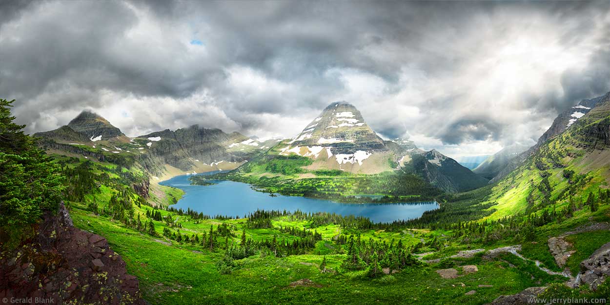
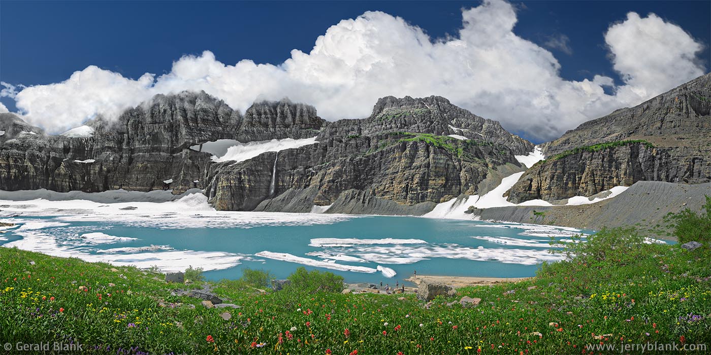
The trail ascends quickly after one passes the sign at the fork by the southwest shore of Lake Josephine. Close to the one-mile point, we reached a point high enough to get the magnificent bird’s-eye view displayed on this page. Angel Wing and Grinnell Lake are the centerpieces of this scene. Toward the east (left side of photo), one can see the Cataract Creek drainage all the way to the peaks of Cataract Mountain and Piegan Mountain.
Toward the west is the Garden Wall on the Continental Divide. The Salamander is a glacier that one can see from the trail. That glacier lies just above Grinnell Glacier and Upper Grinnell Lake, which aren’t visible from lower elevations. But Grinnell Falls below, with its multi-tiered cascades, makes a mighty fine view.
One lake, two waterfalls, and three glaciers —
Click / tap image to view full size
Our last ascent had taken place in 2006, shortly after I purchased my first digital camera. Its built-in zoom lens did not have a view wide enough to take in the entire scene, so I compromised and chose a composition with an interesting foreground, even though it meant cutting out the east half of the lake. I was not really satisfied with the compromise, but at the time I was not acquainted with Photoshop’s image-stitching feature, which I could have used later to create a full panorama in my computer.
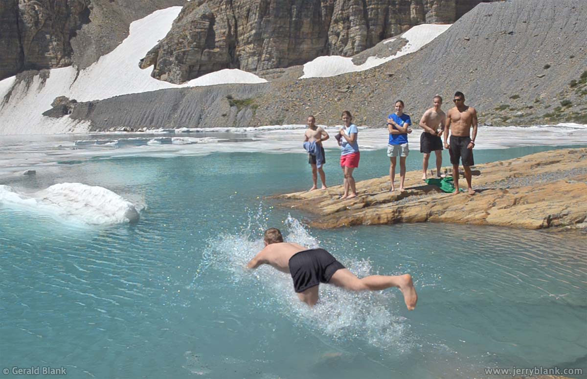
My son jumps in, along with the other students
More importantly, our timing in 2013 was better; we got to the trailhead early, while there was still a place to park, and by the time we reached our “scenic spot”, the Garden Wall had not yet fallen under shadow, except at the top ridge where a few wisps of cloud began to gather moisture from the west side of the Divide. Timing is nearly everything when shooting outdoors, and I am grateful it played in our favor that year.
The remaining three miles of trail is well-maintained, but is fairly steep much of the way, and gets a bit technical toward the top where it climbs over a loose rocky moraine. But the weather stayed sunny and fair, and we were rewarded at trail’s end by the view pictured above, looking over Upper Grinnell Lake to the Continental Divide. The little that remains of Grinnell Glacier is covered with a thin blanket of snow in August; as can be seen in the photo, most of the cirque is filled by the bright turquoise lake and the rocky moraine left by the rapidly-retreating glaciers. Clinging to the arête, in the left side of the photo, one can see what little remains of Gem Glacier. Another glacier named The Salamander is seen in the center, and its meltwater spills over the arête in two ribbon-like waterfalls down to Upper Grinnell Lake.
The lake’s east shore is neither sandy beach nor rocky moraine, but a solid orange-gray shale bench which slopes gently and disappears into the icy water. I was pleasantly surprised by the bright turquoise color of Upper Grinnell Lake, because the photos I had seen made it appear less colorful. The angle of the ambient sunlight, it seems, has something to do with the lake’s appearance.
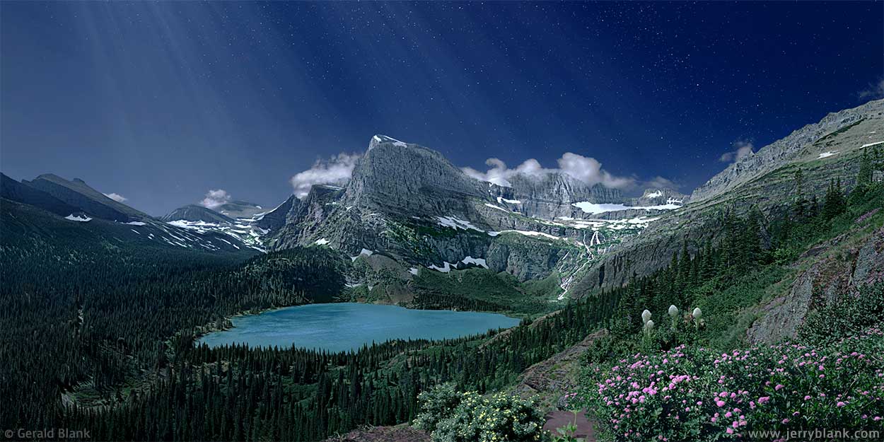
Angel Wing and Grinnell Lake at night — Click / tap image to view full size
The young people visible on the shore in the center of the photo were students from College of the Holy Cross, who had brought their college pennant with them and were debating whether to leave the pennant on the closest ice floe. They decided instead to take turns jumping into the freezing water and swimming a few strokes to the floe; after “tagging” it, they retreated quickly to the sunny rock to regain their breath and dry out.
My son, himself a hardy college student from Minnesota, joined them and gave it a go for the honor of MSU. After he climbed out, seconds later, and could speak again, he confessed: “That is not what I expected it to be!” Once dried out and back in his usual cheerful mood, he decided: “The Old Man should have tried it.” I had to smile. “The Old Man did try it, once, years ago,” I responded. “It was just a tiny pond on a mountain, with no ice. But when I jumped in, you could have heard me yell a mile away.”
The forecast for that evening was for clear skies, and I had toyed with the idea of staying in the high country till after nightfall. I could picture in my mind how the scene might look under moonlight. Alas, my spirit was willing but my body was not so much. After our trek, my lower back was telling me to pack it in for the day. If you’re considering a night trek in Glacier, there are many primitive backcountry campgrounds; unfortunately, none lie close to Grinnell Glacier. Would-be night hikers in the upper Swiftcurrent valley should be experienced trekkers—and should travel in groups, not solo.
I left the idea for a night image on the shelf for a while. Some months later, after applying finishing touches to my daytime panorama of Grinnell Lake with Photoshop, I got a bit bolder and fetched my idea for a night image off the shelf. To accomplish that, I used Photoshop to make the image darker and bluer. Next, I added faux moonlight and stars to the sky.
↑ RETURN TO MAIN MENU AT TOP OF PAGE ↑
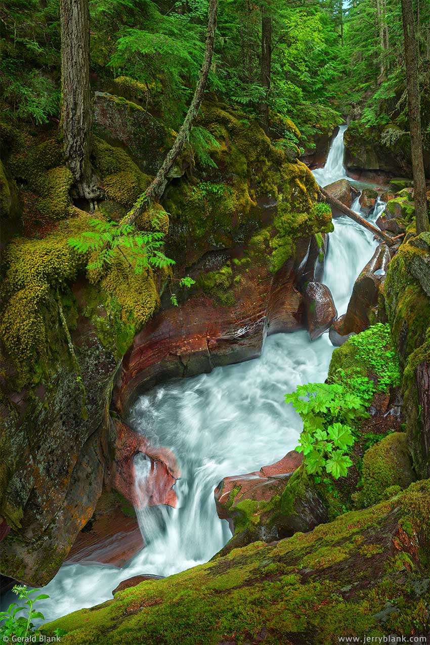
Below the west side of Logan Pass in Glacier National Park, clouds bearing Pacific moisture drop a good portion of their rain between Avalanche Lake and Heaven’s Peak as the clouds bump up against the cold ridge of the Continental Divide. This creates a moist microclimate similar to the Pacific Northwest, and giant cedars tower above Avalanche Creek as its waters cascade down toward Going-To-The-Sun Road.
Avalanche Falls — Click / tap image to view full size
At the head of the Trail of the Cedars, the soil is moist and boggy all summer, and supports a lush growth of moss and ferns. Few places in Montana have such a pristine “Pacific coast” appearance. The Park Service, therefore, created a series of wooden bridges, stairs, and boardwalks to protect the beauty of the area for all who come to visit. The trail to Avalanche Falls is a short, easy trek, which makes it a popular destination for Glacier’s many visitors.
Looking at these images of Avalanche Creek, I still wonder how I could have driven straight past the trail without stopping, for three trips in a row! Not until my fourth visit to Glacier did I realize there was something of great beauty concealed just behind the giant cedars lining the highway below Heaven’s Peak.
At the time I visited the falls with my son, the aforementioned Pacific moisture had rolled in for the afternoon. Thankfully it was a light rain, and not a thunderstorm. But we still had to be cautious; there were few places that weren’t slippery, so we didn’t rush. Each step was chosen carefully.
At the time, there were a few other photographers on the scene, but the usual crowds had retreated to drier parts. Which is just one reason not to despair when an unexpected rainshower dampens a trip to the Rockies. I didn’t have to wait long for my “Kodak moment”— which stretched into 20 or 30 minutes.
I made my way from the base of the falls to the top, capturing the scene in various focal lengths from every possible angle. In that respect, I followed the same game plan as the other photographers on the scene. I’m pretty sure all of us were thinking the same thing: “If I could turn into a squirrel for a few minutes, I could maneuver into the perfect position!”
Looking down at Avalanche Creek
At the time, gripping a wet tree trunk with my left arm while dangling my camera over the gorge with my right arm seemed easier than turning into a squirrel. At that time, affordable camera drones weren’t as ubiquitous as they are now—and if they were, they’re not allowed in national parks anyway.
Looking straight down at the falls, I managed to capture a steady view of the first scene pictured here, where I lowered the camera and captured a close-up view of the moving water.
Most of the other angles I experimented with also suffered from a lack of “depth cues” which are needed to give a flat image the illusion of three-dimensionality. Happily, though, one series of shots had been taken from atop a mossy rock, as seen in whe second photo, which allowed my wide-angle lens to take in the whole scene from front to back. It is from this spot that one sees the falls, not as a single stream of water, but as multiple pools of swirling green water, each pool cascading into the one below it.
The falls almost seem to beckon the viewer from this angle, and if the afternoon had been sunny and hot, my son and I may even have been tempted to jump into the clear, cold water at the top of the falls... so I have one more reason to be grateful it was a cold, rainy day instead!
↑ RETURN TO MAIN MENU AT TOP OF PAGE ↑
At the beginning of August 2013, I met my son near Glacier National Park for our summer vacation, as mentioned above. It had been seven years since our last visit, and we were looking forward to revisiting familiar places and finding new ones. But we brought the rain with us, as they say. It was too wet to attempt any trails in Glacier the following day, but we didn’t mind. It gave us a chance to catch up on things, visit Whitefish and Kalispell, and to get our “game plan” together.

Mountain goat kid resting with Mom — Click / tap image to view full size
Keeping in mind that the plans of outdoorsmen and photographers are subject to change without notice, we reached Logan Pass the afternoon of the following day, and explored the Hidden Lake Trail, which leads travelers westward over the Continental Divide and offers excellent scenery. It was the first time we had come to Montana late enough in the summer to explore the pass; on every prior trip, we arrived early in July and found that the trail was still snow-covered.
Parking space at Logan Pass is something one must take into account if one plans a trip to Glacier, since the park gets more visitors now than it did at the turn of the century. During the summer months, we discovered, the chances of getting a parking spot are better if one arrives at the trailhead at dawn.
As mentioned, we arrived in the afternoon—but we were fortunate, and swooped into a parking spot just as its previous occupant was leaving the Logan Pass visitor center. I was grateful, because the Hidden Lake trail turned out to be as picturesque as I imagined. With the recent retreat of the snow, it was like springtime in August. Never mind that the autumn snows would arrive in a matter of weeks: it was good to be there with my son that day.
Amazing views at Hidden Lake — Click / tap image to view full size
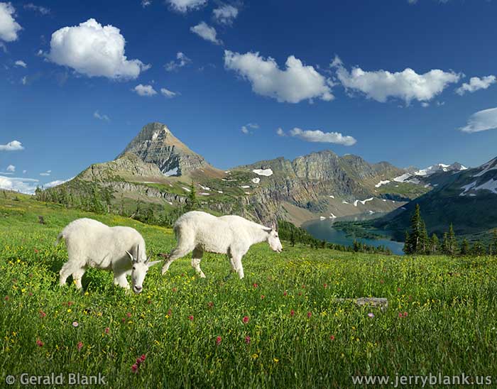
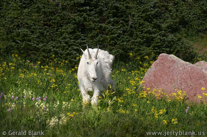
We had already spotted some mountain goats before our hike; in fact, a small herd was causing a small traffic jam below Logan Pass. On the first mile of the trail, we saw individual goats here and there, taking advantage of the abundant greenery covering the meadows which span Hidden Lake Pass at the Continental Divide.
But during that day’s hike, the big wildlife kept its distance. I was less impressed with the goats than with the scenery. I reminded my son of the herd of mountain goats we had seen the previous year at Mount Evans, Colorado. Mount Evans was an excellent location for spotting mountain goats—so much so that I told my son I wouldn’t bother taking goat pictures at Glacier, unless they were just as extraordinary.
A nanny goat we’d seen was within earshot, and apparently overheard my comment. In the few days which followed, I think, she must have repeated it to every other nanny, buck, and billy on the pass.
I intended to return to the same trail three days later—after my son departed for home in Minnesota—but I did not say so out loud.
I returned to Logan Pass on the 6th according to plan, with the intention of following the Hidden Lake trail all the way to the east end, where the waters of the lake plunge down to Hidden Creek far below. You’ll recall, though, that I started this entry by stating that plans are subject to change without notice...
Mountain goat at the Continental Divide — Click / tap image to view full size
I never made it to the end of the trail that afternoon, for I was intercepted along the path by every mountain goat in the neighborhood. The Universe, it seems, has a sense of humor; the goats of Montana apparently had resolved not to be outdone by the goats of Colorado, and posed for me in every possible scenic spot near Hidden Lake Pass! Wildflowers filled the foreground of each scene, and the mountains of the Continental Divide made for a great backdrop. All I needed to do was cooperate and press the shutter release on my camera.
As I mentioned, I hadn’t told a living creature of my plans to return. I am not aware mountain goats can understand English, much less read our minds; but after such a day, I began to wonder.
Just over a mile in, near Hidden Lake Pass, I reached a wooded grotto composed of huge red boulders which had tumbled off the unstable south face of nearby Clements Mountain. Several hikers were peering through the rocks, which was enough reason for me to investigate.
I was rewarded by the touching scene I posted above, of a nanny goat with her kid. I had only enough time to take a few shots, and it was only after returning home and reviewing my photos that I realized how fortunate my timing at the grotto was.
The road construction crews at Glacier had imposed a 9 pm deadline for travelers to get down from Logan Pass before closing the pass for the night. Though I had to forsake my plan of getting to the end of the trail, I beat the 9 pm deadline with five minutes to spare, and I also learned a valuable lesson: I can choose to be open to possibilities. I can never be so experienced that I should close the door on pleasant surprises. Without surprises, life would be so boring!
↑ RETURN TO MAIN MENU AT TOP OF PAGE ↑
On the evening of August 6, I journeyed west over Logan Pass, stopping a couple of times along the way to shoot Bird Woman Falls, a well-known landmark in Glacier, which is visible from Going-To-The-Sun Road. It is flanked by the steep north ridges of Mt. Oberlin and Mt. Cannon, so it receives no direct sunlight most of the time. But when the days are long in summer, those fortunate enough to be driving up the west side of Logan Pass can see the falls in the glow of the early morning or late evening sunlight.
Bird Woman Falls — Click / tap image to view full size
I had tried a few times before to get good photos of Bird Woman Falls, but it seemed I always ended up at Logan Pass before or after the “magic hour”. I was mindful of that as I traveled up the pass once again on the 6th, and stopped at a couple of pullouts and took some “reference” images of the shadowed waterfall. Since my plan was to leave the pass before nightfall, I hoped I’d be able to return to the same pullouts before sunset.
Capturing wildlife photos on the Hidden Lake trail (see blog entry above) proved to be so much fun that I got back to the car later than intended. The sun was sinking like a rock in the west, and the nearby valleys were already under shadow, so I sped down Going-To-The-Sun road as quickly as could be done without crashing my car. I had learned that one can “choose to have enough time”, but those wise words were forgotten in that moment. I was too busy being anxious, fearing time would run out!
I finally found the vantage point I’d scouted earlier, swiftly parked my camera and tripod atop a rough-hewn stone guardrail, and captured as many images of Bird Woman Falls as I could in the last remaining moments before sunset. As can be seen in the photo above, the shadow line was moving quickly up the west face of Mt. Cannon — and a couple of minutes later, only the clouds dissipating above the Continental Divide remained aglow. Darkness was falling on Glacier, but my images were captured and stored safely in a memory card. I had managed to arrive at the perfect time in spite of my hurry and worry. There was just enough shadow to frame the glowing mountain peaks, and the warm light of the setting sun was ideal.
At the time, I assumed the lesson of the day was “Don’t dawdle on the trail!”... but as I write this, I remember the real lesson: One can always choose to have enough time. No one I know of is able to worry themselves into getting better photos!
↑ RETURN TO MAIN MENU AT TOP OF PAGE ↑
On the last day of my trip to Montana’s Glacier National Park in August 2013, I chose to revisit the Hidden Lake Trail which crosses the Continental Divide southwest of Logan Pass. Not far from the Divide, I stopped for a “breather” and glanced at the rock-strewn east slope of Clements Mountain. Amongst the rocks, it seemed to me, was something colorful, and it was obvious that I would have to leave the trail and hike uphill to get a better look.
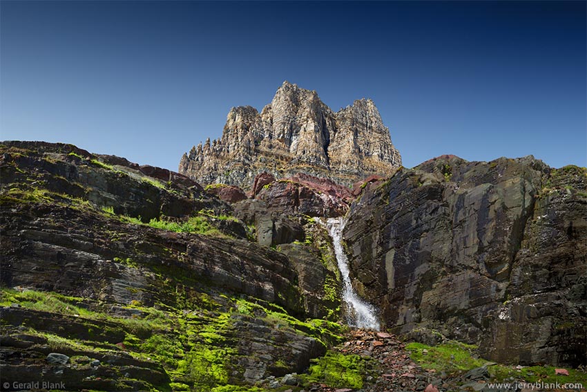
Mossy cascade below Clements Mountain — Click / tap image to view full size
Being a bit stiff and sore from a week’s worth of trekking, I took my time as I picked my way up the loose scree and talus on the lower slopes of the mountain. Had it taken twice as long, it still would have been worth it. The color I had noticed from the trail turned out to be a wide expanse of loose rock covered with bright green moss, crisscrossed everywhere by tiny rivulets of snowmelt from a place farther up and out of my view.
Looking up to the northwest, I could see the jagged upper spires of Clements Mountain rising above a small waterfall. The low cliffs south of the falls were also covered with smaller side-streams of melted snow. The place seemed carpeted in lime green moss all the way to my feet.
I was not yet sure what I would discover at this place, but I unpacked my camera gear and captured photos as I ascended the rocky slopes. Now that I’ve been “there and back again”, I’m able to share the approximate route on this map.
After opening the map, look for the green symbols labeled “Clements Glacier” and “To Clements Glacier”. If you intend to explore this area yourself, please note: As shown in the pictures, this is rough terrain with lots of loose rock. Hiking poles, sturdy footwear, and an excellent sense of balance are required when hiking the lower slopes of Clements Mountain. Experienced hikers will be able to pick out a safe west and/or northwest route to Clements Glacier.
One of the better images can be seen at right. From where I was standing, the layers of rock — and the shadows they cast under the midday sun — form a repeating pattern of diagonal lines. This geometry is common in the Rockies, due to extreme forces which shoved the plates of North America into each other millions of years ago. In cases like this, it makes a photo more interesting, yet I’d hardly noticed the geology when I was standing there. As you’ve probably gathered, I’m easily distracted by bright colors.
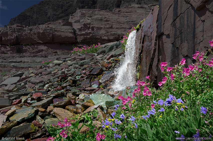
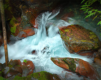
Icy water cascades below Clements — Click / tap image to view full size
To emphasize that point, I’ve posted another picture here. To see what lay above the waterfall I described earlier, I had to do a bit more hiking. Every hundred feet of elevation gain, it seemed, turned the “springtime” clock back another day, and before long, I was facing a wide snowfield I would never have ssen from the trail. Only later did I realize the snowpack was covering what remains of Clements Glacier.
The expanse of snow and ice made the surrounding area pleasantly cool. But the main attraction was the icy water flowing from beneath the snowpack. It coursed past my feet and down the rocks in every direction, bubbling merrily on its way.
In places, the rocks were bigger and the rivulets splashed over them in mini-cascades such as the one in this picture. Surrounded by wildflowers and colorful stones, I found these miniature waterfalls no less beautiful than the grander ones in the valleys far below. Whenever I stopped what I was doing for a moment, I felt an overwhelming sense of gratitude to be there, for it almost seemed that the water sang as it coursed down the cliffs and rocks, and the colors of the wet rocks and the bright wildflowers seemed to have been “kicked up a notch”.
I lacked the time to explore every such cascade on Clements Mountain, but I was lucky to see what I did. It was a great memory to bring home with me, and it’s my pleasure to share it with you. However, it’s also my hope that you can hike the trails of Glacier, if you haven’t done so already. If you have been so fortunate, you will understand me when I say my words and photos can only convey so much!